Rote Wand
- For the children's book series, see Redwall
| Rote Wand | |
|---|---|
 | |
| Highest point | |
| Elevation | 2,704 m (8,871 ft) |
| Prominence | 877 m (2,877 ft) [1] |
| Isolation | 10.9 kilometres (6.8 mi) |
| Coordinates | 47°11′10″N 9°59′06″E / 47.186111°N 9.985°ECoordinates: 47°11′10″N 9°59′06″E / 47.186111°N 9.985°E |
| Geography | |
 Rote Wand Location in the Alps | |
| Location | Vorarlberg, Austria |
| Parent range | Lechquellen Mountains |
| Climbing | |
| First ascent | 12 September 1867 by John Sholto Douglass and Otto Freiherr von Sternbach |
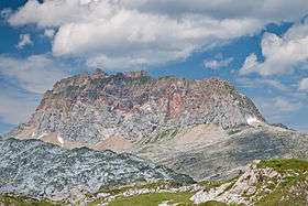
The Rote Wand ("Red Wall") is a mountain in the Lechquellen Mountains range of Vorarlberg, in western Austria.
The second highest mountain at 2,704 m (AA) in the range,[2] behind the lower pit Wildgrubenspitze (2,753 metres (9,032 ft)) in the mountains of Lech sources, it rises from the valley floor between the Großes Walsertal in the north, and Dalaas (Monastery Valley) in the south. The name "Red Wall (Rote Wand)" originates from the distinct red-Lias limestone, which is particularly striking in the south wall. On the north side is a small glacier, the source of the Meng River.
The mountain is a popular hiking destination, but designated only for experienced, sure-footed mountain walkers. The route can be accessed from the Alpe Laguz, Alpe Klesenza, the Freiburger hut and the Formarinsee. All routes lead via a very steep climb up the north-west flank, via the north ridge to the summit.
The first described ascent was by Otto Freiherr von Sternbach and John Sholto Douglass in 1867, following a route explored but not finished by Anton Neyer from Bludenz and the guide Ferdinand Heine in the 1840s. However, the peak had been reached before by unknown climbers as Douglass and Sternbach found a signal pole on the summit. After 1867 the mountain was a popular destination for mountaineers. In 1874 John Sholto Douglass, a native of Vorarlberg of Scottish descent, fell to his death near the Rote Wand while hunting chamois.[3]
In much literature the first ascent is ascribed to David Pappus and companions on 25 July 1610 during his exploration of the borders of the Sonnenberg and Bludenz Counties. Pappus however did not mention this in his detailed account. The "Rote Wand" that he did describe climbing is the 2,105 m high Garsellakopf on the border with Liechtenstein.[4]
References
- ↑ "Rote Wand - peakbagger". peakbagger.com. Retrieved 8 February 2015.
- ↑ Bundesamt für Eich- und Vermessungswesen Österreich: Austrian Map online (Österreichische Karte 1:50.000).
- ↑ Helmut Tiefenthaler, Die Wanderregion Klostertal im Entwicklungsrückblick, Bludenzer Geschichtsblätter 98 (2011)p. 11
- ↑ Manfred Tschaikner, Das Urbar der Herrschaften Bludenz und Sonnenberg von 1620 – ein Überblick, Verba Volant 83 (2012)
| Wikimedia Commons has media related to Red Wall. |