Rossiter Bay
| Rossiter Bay | |
|---|---|
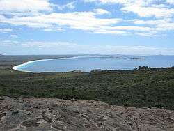 Rossiter Bay from Mississippi Hill, Cape Le Grand National Park, January 2013. | |
| Location | Great Australian Bight |
| Coordinates | 33°57′50″S 122°17′10″E / 33.964°S 122.286°ECoordinates: 33°57′50″S 122°17′10″E / 33.964°S 122.286°E |
| Basin countries | Australia |
Rossiter Bay is on the southern coast of Western Australia, in the Cape Le Grand National Park east of Esperance. The bay is noted as the place where explorer Edward John Eyre and his Aboriginal companion Wylie met the crew of the French whaling ship Mississippi in June 1841, having completed a crossing of the Nullarbor Plain.
It is named for Captain Thomas Rossiter, the Englishman who commanded the Mississippi.[1]
The bay contains a long, curving sandy beach which is often covered with dry seagrass.[2] To the west lies Lucky Bay which was named by Matthew Flinders.
The bay is accessible by conventional vehicle along a road ending in a carpark. This point is the trailhead for the Le Grand Coastal Trail.[3]
See also
References
- ↑ Short, Andrew D. (2004). Beaches of the Western Australian Coast: Eucla to Roebuck Bay, p. 93. Sidney University Press.
- ↑ Bird, Eric, ed. (2010). "Western Australia". Encyclopedia of the World's Coastal Landforms. 2. Springer. p. 1290. ISBN 1402086385. Retrieved 6 July 2013.
- ↑ "Rossiter Bay". Department of Parks and Wildlife. Retrieved 7 July 2013.
This article is issued from
Wikipedia.
The text is licensed under Creative Commons - Attribution - Sharealike.
Additional terms may apply for the media files.