Ross, Minnesota
| Ross, Minnesota | |
|---|---|
| Unincorporated community | |
 Signpost for Ross | |
 Ross, Minnesota Location of the community of Ross within Dieter Township, Roseau County  Ross, Minnesota Ross, Minnesota (the US) | |
| Coordinates: 48°54′22″N 95°55′13″W / 48.90611°N 95.92028°WCoordinates: 48°54′22″N 95°55′13″W / 48.90611°N 95.92028°W | |
| Country | United States |
| State | Minnesota |
| County | Roseau County |
| Township | Dieter Township |
| Elevation | 1,033 ft (315 m) |
| Time zone | UTC-6 (Central (CST)) |
| • Summer (DST) | UTC-5 (CDT) |
| ZIP code | 56751 and 56714 |
| Area code(s) | 218 |
| GNIS feature ID | 650308[1] |
Ross is an unincorporated community in Dieter Township, Roseau County, Minnesota, United States.
The community is located northwest of Roseau near the junction of State Highway 89 (MN 89) and Roseau County Road 10 (350th Street).
Nearby places include Roseau, Badger, Pinecreek, Fox, and Ross Township. The Roseau River flows through the community.
References
Municipalities and communities of Roseau County, Minnesota, United States | ||
|---|---|---|
| Cities | 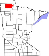 | |
| Townships | ||
| Unorganized territories | ||
| Unincorporated communities | ||
| Ghost town | ||
| Indian reservation | ||
| Footnotes | ‡This populated place also has portions in an adjacent county or counties | |
This article is issued from
Wikipedia.
The text is licensed under Creative Commons - Attribution - Sharealike.
Additional terms may apply for the media files.