Rosebud, Georgia
| Rosebud | |
|---|---|
| Unincorporated community | |
 Rosebud Location within the state of Georgia | |
| Coordinates: 33°47′55″N 83°58′0″W / 33.79861°N 83.96667°WCoordinates: 33°47′55″N 83°58′0″W / 33.79861°N 83.96667°W | |
| Country | United States |
| State | Georgia |
| County | Gwinnett |
| Elevation | 902 ft (275 m) |
| Time zone | UTC-5 (Eastern (EST)) |
| • Summer (DST) | UTC-4 (EDT) |
| GNIS feature ID | 332922[1] |
Rosebud is an unincorporated community located in Gwinnett County, Georgia, United States.
References
Municipalities and communities of Gwinnett County, Georgia, United States | ||
|---|---|---|
| Cities | 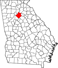 | |
| Towns | ||
| CDP | ||
| Unincorporated communities | ||
| Footnotes | ‡This populated place also has portions in an adjacent county or counties | |
This article is issued from
Wikipedia.
The text is licensed under Creative Commons - Attribution - Sharealike.
Additional terms may apply for the media files.