Rosamond Lake
| Rosamond Lake | |
|---|---|
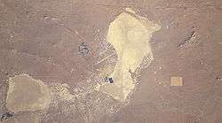 Rosamond (lower left) and Rogers dry lakebeds in Mojave Desert, California | |
| Location |
Mojave Desert Kern County, California Los Angeles County, California |
| Coordinates | 34°49′56″N 118°03′56″W / 34.8322°N 118.0656°WCoordinates: 34°49′56″N 118°03′56″W / 34.8322°N 118.0656°W |
| Lake type | Endorheic basin |
| Basin countries | United States |
| Max. length | 8 km (5.0 mi) |
| Max. width | 9 km (5.6 mi) |
| Surface area | 35 km2 (14 sq mi) |
| Shore length1 | 30 km (19 mi) |
| Surface elevation | 694 m (2,277 ft) |
| Settlements | Edwards Air Force Base |
| References | U.S. Geological Survey Geographic Names Information System: Rosamond Lake |
| 1 Shore length is not a well-defined measure. | |
Rosamond Lake is a natural dry lake bed in the Mojave Desert of Kern- and Los Angeles County, California. The shores of the lake are entirely within the borders of Edwards Air Force Base, approximately 10 miles (16 km) from Lancaster. The lake is adjacent to Rogers Dry Lake which through the Holocene, together made up one large water-body. Piute Ponds are immediately to the southwest.
See also
References
- Public Affairs (25 July 2006). "About Edwards: History: The Dry Lake Beds". Edwards Air Force Base. Archived from the original on 2006-12-07. Retrieved 2009-09-10.
- Reheis, Marith C.; Hershler, Robert; Miller, David M. (2008). Late Cenozoic Drainage History of the Southwestern Great Basin and Lower Colorado River Region: Geologic and Biotic Perspectives. Boulder, Colorado: Geological Society of America. pp. 273–275. ISBN 978-0-8137-2439-3. Retrieved 2009-09-05.
External links
.jpg)
"The Desert Queen" sailing on Rosamond dry lake, 1905
This article is issued from
Wikipedia.
The text is licensed under Creative Commons - Attribution - Sharealike.
Additional terms may apply for the media files.