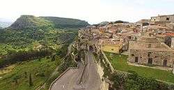
Rometta
| Rometta | |
|---|---|
| Comune | |
| Comune di Rometta | |
 Skyline | |
 Rometta Location of Rometta in Italy | |
| Coordinates: 38°10′N 15°25′E / 38.167°N 15.417°ECoordinates: 38°10′N 15°25′E / 38.167°N 15.417°E | |
| Country | Italy |
| Region | Sicily |
| Metropolitan city | Messina (ME) |
| Frazioni | Rometta Marea, Gimello, Mazzabruno, Santa Domenica, Rapano, San Cono, Sotto Castello, S. Andrea |
| Government | |
| • Mayor | Nicola Merlino |
| Area | |
| • Total | 32.5 km2 (12.5 sq mi) |
| Elevation | 560 m (1,840 ft) |
| Population (30 November 2012)[1] | |
| • Total | 6,532 |
| • Density | 200/km2 (520/sq mi) |
| Demonym(s) | Romettesi |
| Time zone | UTC+1 (CET) |
| • Summer (DST) | UTC+2 (CEST) |
| Postal code | 98043 |
| Dialing code | 090 |
| Patron saint | St. Leo of Catania |
| Saint day | 20 February |
| Website | Official website |
Rometta (Sicilian: Ramietta) is a comune (municipality) in the Metropolitan City of Messina in the Italian region Sicily, located about 180 kilometres (110 mi) east of Palermo and about 12 kilometres (7 mi) west of Messina.
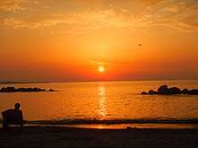
The beach of Rometta facing cape Milazzo and Aeolian islands at the sunset.
Rometta borders the following municipalities: Messina, Monforte San Giorgio, Roccavaldina, Saponara, Venetico, Spadafora.
References
External links

This article is issued from
Wikipedia.
The text is licensed under Creative Commons - Attribution - Sharealike.
Additional terms may apply for the media files.