Romagnano Sesia
| Romagnano Sesia | ||
|---|---|---|
| Comune | ||
| Comune di Romagnano Sesia | ||
| ||
 Romagnano Sesia Location of Romagnano Sesia in Italy | ||
| Coordinates: 45°38′N 8°23′E / 45.633°N 8.383°ECoordinates: 45°38′N 8°23′E / 45.633°N 8.383°E | ||
| Country | Italy | |
| Region | Piedmont | |
| Province | Novara (NO) | |
| Frazioni | Mauletta | |
| Government | ||
| • Mayor | Carlo Bacchetta | |
| Area | ||
| • Total | 18.1 km2 (7.0 sq mi) | |
| Elevation | 266 m (873 ft) | |
| Population (2007)[1] | ||
| • Total | 4,045 | |
| • Density | 220/km2 (580/sq mi) | |
| Demonym(s) | Romagnanesi | |
| Time zone | UTC+1 (CET) | |
| • Summer (DST) | UTC+2 (CEST) | |
| Postal code | 28078 | |
| Dialing code | 0163 | |
| Patron saint | St. Silvanus | |
| Website | Official website | |
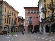
Piazza della Liberta
Romagnano Sesia is a town and comune (municipality) of about 4,000 inhabitants in the Province of Novara in the Italian region Piedmont, located about 80 kilometres (50 mi) northeast of Turin and about 25 kilometres (16 mi) northwest of Novara.
Romagnano Sesia borders the following municipalities: Cavallirio, Fontaneto d'Agogna, Gattinara, Ghemme, Prato Sesia, and Serravalle Sesia.
One of its most famous historical places is the so-called "Cantina dei Santi" (Saints' cellar), that is a room which is the only remaining evidence of the ancient, powerful Benedectine monastery of S. Silano. The Cantina is completely painted with frescos dating back to the 15th century (Biblical story of David and king Saul).
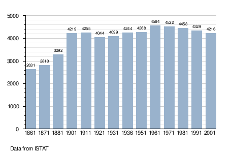
Demographic evolution
References
External links

This article is issued from
Wikipedia.
The text is licensed under Creative Commons - Attribution - Sharealike.
Additional terms may apply for the media files.