Röhrmoos
| Röhrmoos | ||
|---|---|---|
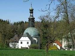 View of the Mariabrunn village, part of Röhrmoos | ||
| ||
 Röhrmoos Location of Röhrmoos within Dachau district 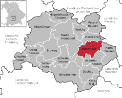 | ||
| Coordinates: 48°20′N 11°29′E / 48.333°N 11.483°ECoordinates: 48°20′N 11°29′E / 48.333°N 11.483°E | ||
| Country | Germany | |
| State | Bavaria | |
| Admin. region | Oberbayern | |
| District | Dachau | |
| Government | ||
| • Mayor | Dieter Kugler (CSU) | |
| Area | ||
| • Total | 31.74 km2 (12.25 sq mi) | |
| Elevation | 505 m (1,657 ft) | |
| Population (2017-12-31)[1] | ||
| • Total | 6,487 | |
| • Density | 200/km2 (530/sq mi) | |
| Time zone | CET/CEST (UTC+1/+2) | |
| Postal codes | 85244 | |
| Dialling codes | 08139 | |
| Vehicle registration | DAH | |
| Website | www.roehrmoos.de | |

Röhrmoos is a municipality in the district of Dachau in Bavaria in Germany. It is located ca. 25 km northwest of München.
Röhrmoos has 14 lots (Gemarkungen):
|
|
|
References
- ↑ "Fortschreibung des Bevölkerungsstandes". Bayerisches Landesamt für Statistik und Datenverarbeitung (in German). September 2018.
Towns and municipalities in Dachau | ||
|---|---|---|
This article is issued from
Wikipedia.
The text is licensed under Creative Commons - Attribution - Sharealike.
Additional terms may apply for the media files.