Altomünster
| Altomünster | ||
|---|---|---|
.jpg) Church of Altomünster | ||
| ||
 Altomünster Location of Altomünster within Dachau district 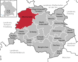 | ||
| Coordinates: 48°23′N 11°15′E / 48.383°N 11.250°ECoordinates: 48°23′N 11°15′E / 48.383°N 11.250°E | ||
| Country | Germany | |
| State | Bavaria | |
| Admin. region | Oberbayern | |
| District | Dachau | |
| Government | ||
| • Mayor | Anton Kerle | |
| Area | ||
| • Total | 75.79 km2 (29.26 sq mi) | |
| Elevation | 518 m (1,699 ft) | |
| Population (2017-12-31)[1] | ||
| • Total | 7,970 | |
| • Density | 110/km2 (270/sq mi) | |
| Time zone | CET/CEST (UTC+1/+2) | |
| Postal codes | 85250 | |
| Dialling codes | 08254 | |
| Vehicle registration | DAH | |
| Website |
www | |

Altomünster is a municipality in the district of Dachau in Bavaria in Germany.
Geography
Geographical location
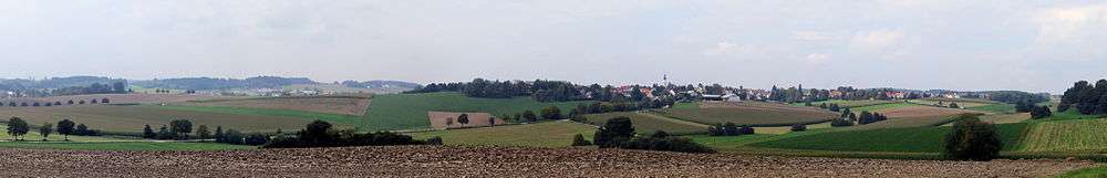
The market is located northwest of Dachau and almost in the middle of the triangle formed by the cities of Munich, Augsburg and Ingolstadt. The village lies on the DAH 2 state road. The Angerbach river flows through Altomünster, which flows into the Zeitlbach.
Municipal structure
Markt Altomünster is organised into the following 48 villages:
Altomünster, Arnberg, Asbach, Breitenau, Deutenhofen, Erlach, Erlau, Freistetten, Haag, Halmsried, Hohenried, Hohenzell, Humersberg, Hutgraben, Irchenbrunn, Kiemertshofen, Lauterbach, Lichtenberg, Maisbrunn, Obererlach, Oberndorf, Oberschröttenloh, Oberzeitlbach, Ottelsburg, Ottmarshausen, Pfaffenhofen, Pipinsried, Plixenried, Radenzhofen, Rametsried, Randelsried, Reichertshausen, Röckersberg, Rudersberg, Ruppertskirchen, Schauerschorn, Schielach, Schloßberg, Schmarnzell, Schmelchen, Sengenried, Stumpfenbach, Teufelsberg, Thalhausen, Übelmanna, Unterzeitlbach, Wollomoos and Xyger.
History
Chronology
In 750 A.D. a wandering monk named Alto came to the area and founded a small monastery.
Before 1000, the Guelphs built a Benedictine monastery. Welf I, Duke of Bavaria brought 1,056 monks to colonize the newly founded monastery vineyard in Altdorf (now Weingarten), while the nuns previously established in Altdorf came to Altomünster. They lived there until the dissolution of the monastery in 1488 by Pope Innocent VIII.
Around 1310, the Wittelsbach dukes awarded the residents town rights.
On 4 October 1391 the market and town rights were confirmed by Duke Stephen III, Duke of Bavaria.
Around 1420, the Ingolstadt dukes built the marketplace.
In 1496, Duke George of Bavaria gave nuns of the Order of St. Bridget of Sweden from Maihingen permission to found a monastery at Altomünster.
On March 18, 1803, the monastery was finally dissolved, although it was later revived. Today, apart from a branch in Bremen, it is the last monastery of the Order of St. Bridget of Sweden in Germany.
In 1823, Altomünster lost its town status and became a rural municipality with market rights. The main reason for this was the closure of the monastery, which had been the main employer paid all the administrative costs.
In 1862 a hospital was built.
In 1869 a kindergarten was built.
In 1882 the Market Savings Bank was founded.
In 1888 Altomünster was connected to the telegraph service, followed in 1902 by the telephone service.
Between 1907 and 1910 the town was electrified.
On 18 December 1913 the Dachau–Altomünster railway opened.
In 1977, a new school complex was inaugurated.
On 1 December 1996 the "Spider" discotheque burnt down - three days after the conviction of the manager and "disco mafia accomplice" Karl Heinz S.[2] Since then, regular Spider revival parties have been held.[3]
Incorporations
| Region | Inhabitants (1970) | Incorporation date | Remarks |
|---|---|---|---|
| Thalhausen | 243 | 1 May 1978[4] | |
| Wollomoos | 478 | 1 May 1978[4] | |
| Pipinsried | 444 | 1 May 1978[4] | Inclusion of 351 444 inhabitants, reclassification of the other inhabitants according to Markt Indersdorf |
| Hohenzell | 435 | 1 May 1978[4] | |
| Kiemertshofen | 146 | 1 January 1977[5] | |
| Oberzeitlbach | 493 | 1 January 1976[5] | |
| Randelsried | 349 | 1 January 1976[5] | Inclusion of 300 349 inhabitants, reclassification of the other inhabitants by Tandern |
| Stumpfenbach | 191 | 1 January 1972[6] |
Politics
Market council
The council of Altomuenster is composed of 20 elected and volunteer council seats and First Mayor of the market. The municipal election held on 16 March 2014 led to the following conclusions:[7]
| Party | Seats |
|---|---|
| CSU | 9 |
| FWG | 10 |
| SPD | 1 |
| Total | 20 |
Education
The Altomünster Primary and Middle School (Volksschule Altomünster) has about 500 pupils. Since October 2011, it has had been part of the Comenius partnership. Declared school partners are the primary school in Crook (England) and the école primaire in Flesselles (France). The project topic is "Healthy Active Citizens Across Europe".
Partnership
References
- ↑ "Fortschreibung des Bevölkerungsstandes". Bayerisches Landesamt für Statistik und Datenverarbeitung (in German). September 2018.
- ↑ Leben und Sterben in Dasing - Wie ein bayerisches Dorf durch vier Morde seine Beschaulichkeit verlor - (Die Zeit dated 13 December 1996)
- ↑ Spider-Revival-Party 2.0 - (Burschenverein Altomünster, retrieved 4 December 2014)
- 1 2 3 4 Statistisches Bundesamt, ed. (in German), Historisches Gemeindeverzeichnis für die Bundesrepublik Deutschland. Namens-, Grenz- und Schlüsselnummernänderungen bei Gemeinden, Kreisen und Regierungsbezirken vom 27. 5. 1970 bis 31. 12. 1982, Stuttgart and Mainz: W. Kohlhammer GmbH, pp. 571, ISBN 3-17-003263-1
- 1 2 3 Statistisches Bundesamt, ed. (in German), Historisches Gemeindeverzeichnis für die Bundesrepublik Deutschland. Namens-, Grenz- und Schlüsselnummernänderungen bei Gemeinden, Kreisen und Regierungsbezirken vom 27. 5. 1970 bis 31. 12. 1982, Stuttgart and Mainz: W. Kohlhammer GmbH, pp. 570, ISBN 3-17-003263-1
- ↑ Wilhelm Volkert (ed.) (1983) (in German), Handbuch der bayerischen Ämter, Gemeinden und Gerichte 1799–1980, Munich: C.H.Beck’sche Verlagsbuchhandlung, pp. 415, ISBN 3-406-09669-7
- ↑ Bayerisches Landesamt für Statistik und Datenverarbeitung
Towns and municipalities in Dachau | ||
|---|---|---|
| Authority control |
|---|