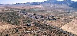
Rodeo, New Mexico
| Rodeo, New Mexico | |
|---|---|
| Census-designated place | |
 | |
 Rodeo  Rodeo | |
| Coordinates: 31°50′13″N 109°1′54″W / 31.83694°N 109.03167°WCoordinates: 31°50′13″N 109°1′54″W / 31.83694°N 109.03167°W | |
| Country | United States |
| State | New Mexico |
| County | Hidalgo |
| Area | |
| • Total | 8.2 sq mi (21.2 km2) |
| • Land | 8.2 sq mi (21.2 km2) |
| • Water | 0.0 sq mi (0.0 km2) |
| Elevation | 4,124 ft (1,257 m) |
| Population (2010) | |
| • Total | 101 |
| • Density | 12/sq mi (4.8/km2) |
| ZIP Code | 88056 |
| Area code(s) | 575 |
| FIPS code | 35-64370 |
| GNIS feature ID | 0894117 |
| Website |
www |
Rodeo is an unincorporated community and census-designated place (CDP) in Hidalgo County in the southwestern corner of New Mexico at 31°50′13″N 109°01′54″W / 31.83694°N 109.03167°W.[1] It lies less than one mile from the border with Arizona on New Mexico State Highway 80. As of the 2010 census, the population of Rodeo was 101.[2]
History
Founded in 1902 as a rail stop on the El Paso and Southwestern Railroad line running from Bisbee, Arizona to El Paso, Texas, it became the center for cattle shipping in the San Simon Valley. Two views exist as to the source of Rodeo's name. One suggests it derives from the Spanish word rodeo, meaning "roundup" or "enclosure", in reference to cattle shipping.[3] However, the noun rodeo is derived from the Spanish verb rodear meaning "to surround" or "to go around".[4] The El Paso and Southwestern railroad runs east across the southern part of the state and after passing through Antelope Pass turns south to Rodeo continuing to Douglas, Arizona, and then north to Bisbee, going around the Chiricahua Mountains.
Geography
Rodeo is in western Hidalgo County, bordering the state of Arizona. New Mexico Highway 80 leads north 30 miles (48 km) to Interstate 10 at Road Forks and southwest 2 miles (3 km) to the state line, continuing as Arizona State Route 80 southwest another 48 miles (77 km) to Douglas, Arizona. Lordsburg, the Hidalgo County seat, is 47 miles (76 km) to the northeast via Highway 80 and I-10.
According to the U.S. Census Bureau, the Rodeo CDP has an area of 8.2 square miles (21.2 km2), all land.[2]
References
- ↑ U.S. Geological Survey Geographic Names Information System: Rodeo, New Mexico
- 1 2 "Geographic Identifiers: 2010 Census Summary File 1 (G001): Rodeo CDP, New Mexico". American Factfinder. U.S. Census Bureau. Retrieved August 25, 2017.
- ↑ "Rodeo: English Spanish Translation | Traductor ingles español". Spanishdict.com. Retrieved 2010-08-27.
- ↑ "Rodear: English Spanish Translation | Traductor ingles español". Spanishdict.com. Retrieved 2010-08-27.
Further reading
- Julyan, Robert Hixson (1996). The place names of New Mexico. Albuquerque: University of New Mexico Press. p. 302. ISBN 978-0-8263-1689-9.
- Gomez, M.E. (JR.) (2009). The Other Rodeo. published by Talbotland Inc. p. 146.
External links
Municipalities and communities of Hidalgo County, New Mexico, United States | ||
|---|---|---|
| City | 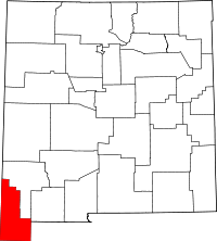 | |
| Village | ||
| CDPs | ||
| Other unincorporated communities | ||
| Ghost towns | ||