Rockledge, Georgia
| Rockledge, Georgia | |
|---|---|
| Unincorporated community | |
 Rockledge, Georgia | |
| Coordinates: 32°26′35″N 82°41′51″W / 32.44306°N 82.69750°WCoordinates: 32°26′35″N 82°41′51″W / 32.44306°N 82.69750°W | |
| Country | United States |
| State | Georgia |
| County | Laurens |
| Elevation | 217 ft (66 m) |
| Time zone | UTC-5 (Eastern (EST)) |
| • Summer (DST) | UTC-4 (EDT) |
| ZIP code | 30454 |
| Area code(s) | 478 |
| GNIS feature ID | 321774[1] |
Rockledge is an unincorporated community in Laurens County, Georgia, United States. The community is located along a CSX Transportation line near Georgia State Route 29, 13.8 miles (22.2 km) east-southeast of Dublin. Rockledge has a post office with ZIP code 30454.[2][3]
References
- ↑ "Rockledge". Geographic Names Information System. United States Geological Survey.
- ↑ United States Postal Service. "USPS - Look Up a ZIP Code". Retrieved May 25, 2015.
- ↑ "Postmaster Finder - Post Offices by ZIP Code". United States Postal Service. Retrieved May 25, 2015.
Municipalities and communities of Laurens County, Georgia, United States | ||
|---|---|---|
| Cities | 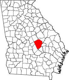 | |
| Towns | ||
| Unincorporated communities | ||
| Ghost town | ||
| Footnotes | ‡This populated place also has portions in an adjacent county or counties | |
This article is issued from
Wikipedia.
The text is licensed under Creative Commons - Attribution - Sharealike.
Additional terms may apply for the media files.