Roche Faurio
| Roche Faurio | |
|---|---|
 Roche Faurio on the left | |
| Highest point | |
| Elevation | 3,730 m (12,240 ft) |
| Coordinates | 44°56′30″N 6°21′26″E / 44.94167°N 6.35722°ECoordinates: 44°56′30″N 6°21′26″E / 44.94167°N 6.35722°E |
| Geography | |
 Roche Faurio Location in the Alps | |
| Location | Isère, France |
| Parent range | Dauphiné Alps |
| Climbing | |
| First ascent | 1873 |
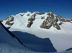
Roche Faurio (3,730m) is a mountain of the Massif des Écrins in the Dauphiné Alps in Isère, France. It lies in front of the mighty north face of the Barre des Écrins and towers over the Glacier Blanc. The mountain lies inside the Écrins National Park. It is a popular summit with hikers, taking about four hours to climb from the Écrins Hut, and ski mountaineers.[1]
References
- ↑ "Roche Faurio - summitpost". summitpost.org. Retrieved 9 February 2015.
This article is issued from
Wikipedia.
The text is licensed under Creative Commons - Attribution - Sharealike.
Additional terms may apply for the media files.