Roccamorice
| Roccamorice | ||
|---|---|---|
| Comune | ||
| Comune di Roccamorice | ||
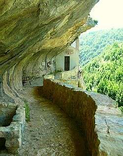 Hermitage of St. Bartholomew | ||
| ||
 Roccamorice Location of Roccamorice in Italy | ||
| Coordinates: 42°13′N 14°2′E / 42.217°N 14.033°E | ||
| Country | Italy | |
| Region | Abruzzo | |
| Province | Pescara (PE) | |
| Frazioni | Collarso, Pagliari, Piano delle Castagne | |
| Government | ||
| • Mayor | Alessandro D'Ascanio | |
| Area | ||
| • Total | 24 km2 (9 sq mi) | |
| Elevation | 520 m (1,710 ft) | |
| Population (1 January 2007)[1] | ||
| • Total | 1,012 | |
| • Density | 42/km2 (110/sq mi) | |
| Demonym(s) | Roccolani | |
| Time zone | UTC+1 (CET) | |
| • Summer (DST) | UTC+2 (CEST) | |
| Postal code | 65020 | |
| Dialing code | 085 | |
| ISTAT code | 068034 | |
| Website | Official website | |
Roccamorice is a town and comune in the province of Pescara, Abruzzo, central Italy.
It’s distinctive shape is created by the imprint of the Lavino and Lanello rivers, both of which have dried up.
Many of it's inhabitants emigrated to Canada and the USA in the early 20th century until the 1960s.
Some establishments are so old, the buildings do not have addresses.
See also
References

This article is issued from
Wikipedia.
The text is licensed under Creative Commons - Attribution - Sharealike.
Additional terms may apply for the media files.