Robson Valley
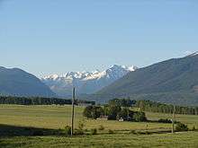
The Robson Valley is a geographic region of the Canadian province of British Columbia,[1] comprising the section of the Rocky Mountain Trench that lies southeast of the city of Prince George following the Fraser River to the Yellowhead Pass. The name is derived from Mount Robson, which stands near the entrance to the Yellowhead Pass. Communities in the Robson Valley include the settlements of Dome Creek, Crescent Spur, Dunster, and Tête Jaune Cache, with larger population concentrations in the villages of McBride and Valemount. On a map, the Robson Valley is located immediately south of the elbow in the boundary between Alberta and British Columbia. Transportation corridors through the Robson Valley include the CN rail lines, and highways 16 and 5.
The Robson Valley is bounded on the south by the Columbia Country, farther south down the Rocky Mountain Trench, and the Thompson Country, via Canoe Pass, and is flanked on its east by the Rocky Mountains and on the west by the Cariboo Mountains.
First Nations
Within the Robson Valley region, there are eight traditional First Nations groups: Lheidli T’enneh First Nation, Simpcw First Nation, Lhtako Dene Nation, Canim Lake Indian Band, Xat’súll First Nation (Soda Creek), Shuswap First Nation, Okanagan First Nation, Tsilhqot’in.[2]
The Railway
The railway served as part of the foundation of the Robson Valley. When the railway was built, two divisional points existed, one at Lucerne and the other at McBride, or Mile 90 as it was called.[3] The railway that went through the Robson Valley comprised the Grand Trunk Pacific and Canadian Northern Railway, later to become, between 1918-1923, the Canadian National Railway.[4]
References
- ↑ BC Names entry "Robson Valley"
- ↑ Government of British Columbia. Robson Valley Timber Supply Area. Victoria, B.C.: Ministry of Forests, Lands, and Natural Resource Operations, 2012.
- ↑ Wheeler, Marilyn J. (1979). The Robson Valley Story. McBride: The McBride Robson Valley Story Group. p. 1.
- ↑ Wheeler, Marilyn J. (1979). The Robson Valley Story. McBride: The McBride Robson Valley Story Group. p. 3.
Coordinates: 53°15′00″N 120°00′00″W / 53.25000°N 120.00000°W