Roborough Castle
Coordinates: 51°11′56″N 3°48′47″W / 51.199°N 3.813°W
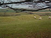
Site of Roborough Castle.
Roborough Castle is an Iron Age enclosure or hill fort situated close to Lynton in Devon, England. The fort is situated on the North East edge of a Hillside forming a promontory above a tributary to the East Lyn River known as Hoaroak Water at approx 320 Metres above Sea Level.[1] [2]
References
- ↑ Sellman, R.R. (1985). "The Iron Age in Devon (ch.2)". Aspects of Devon History. Exeter: Devon Books. pp. 11 (Map of Iron Age hill forts in Devon includes Roborough Castle). ISBN 0-86114-756-1.
- ↑ Whybrow, Charles (1970). "The Early Iron Age (ch.4)". Antiquary's Exmoor. Dulverton: Exmoor Press. pp. 23 (Mention of Roborough Castle as an example of a 'round' enclosure). ISBN 0-9500133-4-X.
| Wikimedia Commons has media related to Roborough Castle. |
This article is issued from
Wikipedia.
The text is licensed under Creative Commons - Attribution - Sharealike.
Additional terms may apply for the media files.