Robert E. Lee Memorial Bridge
| Robert E. Lee Memorial Bridge | |
|---|---|
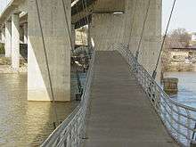 Robert E. Lee Memorial Bridge viewed from underneath, showing footbridge to Belle Isle. | |
| Coordinates | 37°31′49″N 77°27′02″W / 37.5302°N 77.4506°WCoordinates: 37°31′49″N 77°27′02″W / 37.5302°N 77.4506°W |
| Carries |
|
| Crosses | James River |
| Locale | Richmond, Virginia |
| Official name | Robert E. Lee Memorial Bridge |
| Other name(s) | Lee Bridge |
The Robert E. Lee Memorial Bridge in Richmond, Virginia carries U.S. Route 1 and U.S. Route 301 across the James River at the Fall Line.
The city acquired the original bridge from Richmond Bridge Corp in 1933, and it was named the James River Bridge but was later renamed for the Confederate general.[1] It was originally constructed as a four lane toll facility and opened in 1934. In the 1980s, a replacement structure was built including a substantial realignment of the approach roadways at the south end. Work was completed in 1989.[2][3] It is toll-free and includes 3 lanes in either direction. An on-ramp and an off-ramp for South 2nd Street connects to the bridge over the north shore of the James River.[4] The Virginia War Memorial is located adjacent to its northern end.
A notable feature is a pedestrian footbridge which hangs below the road deck from Tredegar Street near the site of the Tredegar Iron Works on the north shore over to Belle Isle in the middle of the river.
See also


- List of crossings of the James River
References
- ↑ "Southside Richmond Landmarks and Neighborhoods". SouthsideRichmond.org. Retrieved 11 May 2017.
- ↑ "Richmond Riverfront Plan" (PDF). City of Richmond. 26 November 2012. Retrieved 11 May 2017.
- ↑ Kappatos, Nicole. "From the Archives: The old Lee Bridge". Richmond Times Dispatch. Retrieved 27 September 2018.
In 1985, the bridge was completely rebuilt as part of a $32 million project (and ended up costing more than $43.5 million). The new bridge created a six-lane replacement for the then-51-year-old bridge. The new bridge was dedicated in November 1988.
- ↑ Google (October 24, 2011). "Robert E. Lee Memorial Bridge" (Map). Google Maps. Google. Retrieved October 24, 2011.
Crossings of the James River | ||||
|---|---|---|---|---|
| ||||
Coordinates: 37°31′49″N 77°27′02″W / 37.5302082°N 77.4506092°W