Robert E. Lee Campground
| Robert E. Lee Campground | |
| Protected Area | |
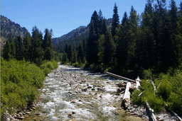 North Fork Boise River at Deer Park Cabin near Robert E. Lee Campground | |
| Country | United States |
|---|---|
| State | Idaho |
| County | Boise |
| River | North Fork Boise River |
| Location | Boise National Forest |
| - elevation | 4,800 ft (1,463 m) |
| - coordinates | 43°54′20″N 115°26′04″W / 43.90556°N 115.43444°WCoordinates: 43°54′20″N 115°26′04″W / 43.90556°N 115.43444°W |
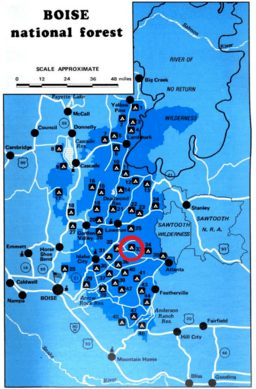 Boise National Forest map with Robert E. Lee Campground highlighted | |
Robert E. Lee Campground is a United States Forest Service campground in the Boise National Forest about 40 miles (64 km) east of the state capital, Boise.[1] It is situated at North Fork Boise River river mile 19, at the confluence of Robert E. Lee Creek, a short tributary.[2] The campground and creek, both named for General Robert E. Lee, are the only two Confederate memorials in the U.S. state of Idaho.[3][4] It is at 4,800 feet (1,500 m) in elevation and has six campsites.[5]
References
- ↑ U.S. Geological Survey Geographic Names Information System: Robert E Lee Campground
- ↑ Bear River 1:24,000 topographic quad, United States Geological Survey, Map Reference Code (MRC) 43115H4
- ↑ "Whose Heritage? Public symbols of the Confederacy" (PDF). Southern Poverty Law Center. p. 22.
- ↑ Legacy of the Civil War in Idaho, KTVB television, August 15, 2017
- ↑ Camp and Picinic in the National Forests of the Intermountain Region, United States. Forest Service, 1981, p. 46
This article is issued from
Wikipedia.
The text is licensed under Creative Commons - Attribution - Sharealike.
Additional terms may apply for the media files.