Roßtal
| Roßtal | ||
|---|---|---|
| ||
 Roßtal Location of Roßtal within Fürth district 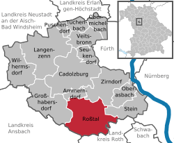 | ||
| Coordinates: 49°24′N 10°53′E / 49.400°N 10.883°ECoordinates: 49°24′N 10°53′E / 49.400°N 10.883°E | ||
| Country | Germany | |
| State | Bavaria | |
| Admin. region | Mittelfranken | |
| District | Fürth | |
| Government | ||
| • Mayor | Johann Völkl (SPD) | |
| Area | ||
| • Total | 44.40 km2 (17.14 sq mi) | |
| Elevation | 373 m (1,224 ft) | |
| Population (2017-12-31)[1] | ||
| • Total | 9,699 | |
| • Density | 220/km2 (570/sq mi) | |
| Time zone | CET/CEST (UTC+1/+2) | |
| Postal codes | 90574 | |
| Dialling codes | 09127 | |
| Vehicle registration | FÜ | |
| Website |
www | |

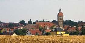
St. Laurentius' church in Roßtal
Roßtal is a market town in the district of Fürth, Bavaria, Germany. As of 2003 it had a population of 10,010.
References
- ↑ "Fortschreibung des Bevölkerungsstandes". Bayerisches Landesamt für Statistik und Datenverarbeitung (in German). September 2018.
External links
| Wikimedia Commons has media related to Roßtal. |
- Official website (in German)
Towns and municipalities in Fürth (district) | ||
|---|---|---|
This article is issued from
Wikipedia.
The text is licensed under Creative Commons - Attribution - Sharealike.
Additional terms may apply for the media files.