Rivière du Cap Rouge
| Cap-Rouge river | |
|---|---|
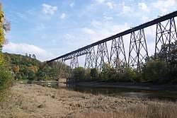 The river passing under the Cap-Rouge trestle | |
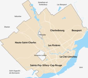 Location of the mouth of the river in Quebec City | |
| Native name | Rivière du Cap-Rouge |
| Country | Canada |
| Province | Quebec |
| Region | Capitale-Nationale |
| Cities | Quebec City, Saint-Augustin-de-Desmaures |
| Physical characteristics | |
| River mouth |
Saint Lawrence River Cap-Rouge 46°44′55″N 71°20′35″W / 46.7486111°N 71.3430556°W[1][2]Coordinates: 46°44′55″N 71°20′35″W / 46.7486111°N 71.3430556°W[1][2] |
| Length | 23.5 km (14.6 mi) |
| Basin features | |
| River system | Saint Lawrence River |
| Basin size | 82 km2 (32 sq mi) |
| Bridges | Cap-Rouge trestle |
The Cap-Rouge river (French: Rivière du Cap Rouge) is a river in the Sainte-Foy–Sillery–Cap-Rouge borough of Quebec City and in the city of Saint-Augustin-de-Desmaures, both cities in the Capitale-Nationale region of Quebec, Canada.[1][2][3]
The river begins on the slopes of Mount Bélair, at the foothills of the Laurentian Mountains, and flows 23.5 kilometres (14.6 mi) before ending in the Quebec City neighbourhood of Cap-Rouge as a left tributary of the Saint Lawrence River.[3] It is also at the junction of those rivers that is located the archeological site of Charlesbourg-Royal, the earliest known French settlement in North America.[4]
Its 82-square-kilometre (32 sq mi) watershed also encompasses parts of La Jacques-Cartier Regional County Municipality, L'Ancienne-Lorette, La Haute-Saint-Charles and Saint-Augustin-de-Desmaures.[3], where agricultural activities are found and which puts the river at risk of agricultural pollution. Measurements of ammoniacal nitrogen, nitrate and phosphorus were however all classified as "good" in 2016.[5]
References
- 1 2 3 "Rivière du Cap Rouge". Geographical Names Data Base. Natural Resources Canada. Retrieved 2018-10-09.
- 1 2 3 "Rivière du Cap Rouge". Banque de noms de lieux du Québec (in French). Commission de toponymie du Québec. 1968-12-05. Retrieved 2018-10-09.
- 1 2 3 Gaudette, Nathalie; Lavoie, Isabelle; Leblanc, Chantal (December 2009). "Portrait du bassin versant de la rivière du Cap Rouge" [Portrait of the Cap-Rouge river watershed] (PDF) (in French). Conseil de bassin de la rivière du Cap Rouge. Retrieved 2018-10-09.
- ↑ "Fort Charlesbourg Royal National Historic Site of Canada". Parks Canada. Retrieved 2018-10-10.
- ↑ Péroline Lescot. "Suivi de la qualité de l'eau des rivières Lorette et du Cap Rouge en milieu agricole – Saison 2016" (PDF). Organisme des bassins versants de la Capitale (pdf) (in French). p. 19. Retrieved 2018-10-10.