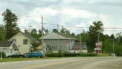
Rivière-Héva, Quebec
| Rivière-Héva | |
|---|---|
| Municipality | |
 | |
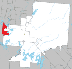 Location within La Vallée-de-l'Or RCM. | |
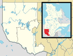 Rivière-Héva Location in western Quebec. | |
| Coordinates: 48°14′N 78°13′W / 48.233°N 78.217°WCoordinates: 48°14′N 78°13′W / 48.233°N 78.217°W[1] | |
| Country |
|
| Province |
|
| Region | Abitibi-Témiscamingue |
| RCM | La Vallée-de-l'Or |
| Settled | 1935 |
| Constituted | January 1, 1982 |
| Government[2] | |
| • Mayor | Réjean Guay |
| • Federal riding |
Abitibi—Baie-James— Nunavik—Eeyou |
| • Prov. riding | Abitibi-Est |
| Area[2][3] | |
| • Total | 489.50 km2 (189.00 sq mi) |
| • Land | 425.33 km2 (164.22 sq mi) |
| Population (2011)[3] | |
| • Total | 1,433 |
| • Density | 3.4/km2 (9/sq mi) |
| • Pop 2006-2011 |
|
| • Dwellings | 656 |
| Time zone | UTC−5 (EST) |
| • Summer (DST) | UTC−4 (EDT) |
| Postal code(s) | J0Y 2H0 |
| Area code(s) | 819 |
| Highways |
|
Rivière-Héva is a municipality in northwestern Quebec, Canada in the MRC de La Vallée-de-l'Or. It is named after the Héva River that flows through the municipality.
History
In 1935 as part of the Vautrin Settlement Plan, the place was colonized, originally called Aux Quatre-Coins (French for "At Four Corners"). In 1981, it was incorporated as a municipality.[1]
On August 29, 2009, Rivière-Héva was greatly enlarged when it absorbed the Unorganized Territory of Lac-Fouillac and the western portion of the Unorganized Territory of Lac-Granet.[4]
Demographics
Population trend:[5]
- Population in 2006:
- Rivière-Héva: 1056 (2001 to 2006 population change: -5.6 %)
- Lac-Fouillac: 91
- Population in 2001:
- Rivière-Héva: 1119
- Lac-Fouillac: 77
- Population in 1996:
- Rivière-Héva: 1096
- Lac-Fouillac: 174
- Population in 1991:
- Rivière-Héva: 1043
- Lac-Fouillac: 168
Mother tongue:[6]
- English as first language: 0%
- French as first language: 100%
- English and French as first language: 0%
- Other as first language: 0%
References
- 1 2 "Rivière-Héva (Municipalité)" (in French). Commission de toponymie du Québec. Retrieved 2011-01-12.
- 1 2 "Rivière-Héva". Répertoire des municipalités (in French). Ministère des Affaires municipales, des Régions et de l'Occupation du territoire. Retrieved 2011-01-12.
- 1 2 "Rivière-Héva census profile". 2011 Census data. Statistics Canada. Retrieved 2011-01-12.
- ↑ Institut de la statistique du Québec, Modifications aux municipalités du Québec Août 2009, Québec, ISSN 0843-8250
- ↑ Statistics Canada: 1996, 2001, 2006, 2011 census
- ↑ "Rivière-Héva community profile". 2006 Census data. Statistics Canada. Retrieved 2011-01-12.
Adjacent Municipal Subdivisions | |
|---|---|
| Cities | |
|---|---|
| Municipalities | |
| Parishes | |
| Unorganized territories | |
| |
This article is issued from
Wikipedia.
The text is licensed under Creative Commons - Attribution - Sharealike.
Additional terms may apply for the media files.