Riverview Estates, Missouri
| Riverview Estates, Missouri | |
|---|---|
| Village | |
 Riverview Estates | |
| Coordinates: 38°44′55″N 94°31′34″W / 38.74861°N 94.52611°WCoordinates: 38°44′55″N 94°31′34″W / 38.74861°N 94.52611°W | |
| Country | United States |
| State | Missouri |
| County | Cass |
| Area[1] | |
| • Total | 0.24 sq mi (0.62 km2) |
| • Land | 0.24 sq mi (0.62 km2) |
| • Water | 0 sq mi (0 km2) |
| Elevation | 950 ft (290 m) |
| Population (2010)[1] | |
| • Total | 82 |
| • Estimate (2016)[2] | 83 |
| • Density | 340/sq mi (130/km2) |
| Time zone | UTC-6 (Central (CST)) |
| • Summer (DST) | UTC-5 (CDT) |
| Area code(s) | 816 |
| FIPS code | 29-62210[1] |
| GNIS feature ID | 2417409[3] |
Riverview Estates is a village in Cass County, Missouri, United States. The population was 82 at the 2010 census.[1]
Geography
The village is located in northwestern Cass County at 38°44′55″N 94°31′34″W / 38.74861°N 94.52611°W.[4] It is part of the Kansas City Metropolitan Area and is 4 miles (6 km) south of Belton and 6 miles (10 km) northwest of Peculiar. The West Fork of East Creek flows through the eastern part of the village.
According to the United States Census Bureau, the village has a total area of 0.24 square miles (0.62 km2), all land.[1]
Demographics
| Historical population | |||
|---|---|---|---|
| Census | Pop. | %± | |
| 2010 | 82 | — | |
| Est. 2016 | 83 | [2] | 1.2% |
| U.S. Decennial Census[5] | |||
References
- 1 2 3 4 5 "Geographic Identifiers: 2010 Demographic Profile Data (G001): Riverview Estates village, Missouri". U.S. Census Bureau, American Factfinder. Retrieved October 8, 2014.
- 1 2 "Population and Housing Unit Estimates". Retrieved June 9, 2017.
- ↑ U.S. Geological Survey Geographic Names Information System: Riverview Estates, Missouri
- ↑ "US Gazetteer files: 2010, 2000, and 1990". United States Census Bureau. 2011-02-12. Retrieved 2011-04-23.
- ↑ "Census of Population and Housing". Census.gov. Retrieved June 4, 2015.
Municipalities and communities of Cass County, Missouri, United States | ||
|---|---|---|
| Cities | 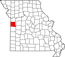 | |
| Villages | ||
| Townships | ||
| Unincorporated communities | ||
| Ghost towns | ||
| Footnotes | ‡This populated place also has portions in an adjacent county or counties | |
This article is issued from
Wikipedia.
The text is licensed under Creative Commons - Attribution - Sharealike.
Additional terms may apply for the media files.