Riverland Terrace
Riverland Terrace, developed started in 1925,[1] is one of James Island, South Carolina's oldest neighborhoods; Wappoo Hall was created shortly before Riverland Terrace.[2] The Terrace is located just 10 minutes west of downtown Charleston, South Carolina along Wappoo Creek and the inland waterway. The neighborhood boasts a public boat landing, Charleston Municipal Golf Course, a playground, five restaurants and numerous antique shops.
Leading into the neighborhood is the historic Avenue of Oaks, consisting of 73 live oak trees believed to be over 100 years old. The avenue of oaks had been begun about 1910, and the developers completed the installation of the oaks during the landscaping of the neighborhood starting in 1925.[3] Fort Pemberton, a Civil War fortification built in 1862, remains today.
The Terrace consists of approximately 800 homes. Sizes and prices vary greatly. Starter homes of 900 square feet (84 m2) begin at $200,000 up to 4 plus million for deep water lot homes and everything in between. Riverland Terrace has an active neighborhood association that meets 3-4 times each year. The community actively works to preserve the historical integrity of the community, thus contributing to the hometown feel.
The Riverland Terrace Neighborhood Association
The Riverland Terrace Neighborhood Association (RTNA) is a not-for-profit volunteer neighborhood organization for those who live, work, or play within Riverland Terrace. RTNA is committed to promoting and protecting the beauty, safety, stability, cleanliness, and social and economic viability of the neighborhood by fostering alliances with the local residents, merchants, and government officials. RTNA seeks to represent community interests as a single voice.
Gallery
 Oak trees over 100 years old line the entrance to Riverland Terrace
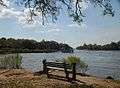 The Wappoo Cut which borders one side of neighborhood
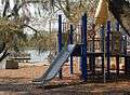 Plymouth Park
References
- ↑ "Development of Riverland Terrace Area". Charleston, South Carolina: Evening Post. October 24, 1925. p. 1.
- ↑ "Improvements at Riverland". Charleston, South Carolina: Evening Post. November 9, 1925. p. 10.
- ↑ "Riverland Terrace Is Developing". Charleston, South Carolina: News and Courier. November 12, 1925. p. 10.
External links
Coordinates: 32°45′43″N 79°59′25″W / 32.76194°N 79.99028°W