River Meese
| Meese | |
| River | |
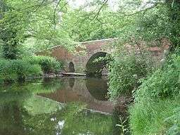 River Meese near Cherrington | |
| Country | England |
|---|---|
| Source | |
| - location | Weston-under-Lizard |
| - elevation | 123 m (404 ft) |
| - coordinates | 52°41′33″N 2°15′40″W / 52.6926°N 2.2610°W |
| Secondary source | |
| - location | Aqualate Mere |
| Mouth | |
| - location | River Tern near Great Bolas |
| - elevation | 54 m (177 ft) |
| - coordinates | 52°47′01″N 2°32′14″W / 52.7836°N 2.5372°WCoordinates: 52°47′01″N 2°32′14″W / 52.7836°N 2.5372°W |
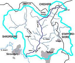 Map showing the River Meese, the other tributaries of the River Tern, and its drainage basin | |
The River Meese is a river in Shropshire, England. It is a tributary of the River Tern, itself a tributary of the River Severn.
The river is only known as the Meese below Aqualate Mere, but its source lies considerably higher via the stream known successively as Dawford Brook, Lynn Brook, Moreton Brook, Back Brook, and Coley Brook, which flows north from its source near the Roman Watling Street (now the A5) just to the east of Weston-under-Lizard until it reaches Aqualate Mere.[1]
For around 2 kilometres (1.2 mi) near Newport, Shropshire it forms the border between Shropshire and Staffordshire, where it is joined by Lonco Brook from the north.
References
- ↑ Ordnance Survey of Great Britain
This article is issued from
Wikipedia.
The text is licensed under Creative Commons - Attribution - Sharealike.
Additional terms may apply for the media files.