Ritzlihorn
| Ritzlihorn | |
|---|---|
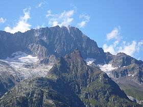 Ritzlihorn seen from Gelmersee (in the foreground is the Stampfhoren) | |
| Highest point | |
| Elevation | 3,282 m (10,768 ft) |
| Prominence | 342 m (1,122 ft) [1] |
| Isolation | 5.84 kilometres (3.63 mi) |
| Parent peak | Finsteraarhorn |
| Coordinates | 46°38′0.5″N 8°15′31.4″E / 46.633472°N 8.258722°ECoordinates: 46°38′0.5″N 8°15′31.4″E / 46.633472°N 8.258722°E |
| Geography | |
 Ritzlihorn Location in Switzerland | |
| Location | Bern, Switzerland |
| Parent range | Bernese Alps |
| Climbing | |
| First ascent | 1816 by Johann Jakob Frey [2] |
The Ritzlihorn (3,282 m) is a mountain of the Bernese Alps, overlooking Handegg in the canton of Bern. It lies on the range east of the Gauli Glacier and north of the Bächlistock.
References
- ↑ Retrieved from the Swisstopo topographic maps and Google Earth. The key col is the Gruebenjoch (2,940 m).
- ↑ Paul Caminada, Pioniere der Alpentopographie: die Geschichte der Schweizer Kartenkunst, AS Verlag, 2003. Page 179
External links
| Wikimedia Commons has media related to Ritzlihorn. |
This article is issued from
Wikipedia.
The text is licensed under Creative Commons - Attribution - Sharealike.
Additional terms may apply for the media files.