Mayaro–Rio Claro
| Mayaro–Rio Claro | |
| MRCRC | |
| Regional Corporation | |
 Logo of the Mayaro-Rio Claro Regional Corporation. | |
| Official name: Region of Mayaro–Rio Claro | |
| Country | |
|---|---|
| Counties | Mayaro and Nariva |
| Coastline | Atlantic Ocean |
| Borders on | Princes Town, Sangre Grande, Couva-Tabaquite-Talparo |
| Capital | Mayaro |
| - center | South Trinidad |
| - elevation | 0 m (0 ft) |
| Lowest point | |
| - location | Atlantic Ocean, Trinidad and Tobago |
| - elevation | 0 m (0 ft) |
| Area | 814 km2 (314 sq mi) |
| Population | 35,650 (2011) |
| Density | 44/km2 (114/sq mi) |
| Founded | 1990 |
| Government | |
| - location | Rio Claro |
| Leader | Glen Ram |
| Timezone | Atlantic Standard Time (UTC-4) |
| - summer (DST) | -4 |
| Area code | +1 (868) 630, 644 |
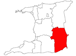 Location of Mayaro-Rio Claro in Trinidad | |
| Website: http://mayarorioclaro.com/ | |
Mayaro–Rio Claro is a region of Trinidad. The local government body is Mayaro–Rio Claro Regional Corporation, a Regional Corporation of Trinidad and Tobago. The region has a land area of 852.81 km². The Rio Claro–Mayaro Regional Corporation is headquartered in Rio Claro. Other towns include Mayaro and Guayaguayare. The region possesses many beaches front and Trinidad's largest reservoir of natural gas and crude oil along its eastern coast.
Mayaro–Rio Claro Regional Corporation
The Corporation’s area of responsibility comprises 39 discrete communities. It has the second largest landmass of any Regional Corporation in Trinidad. The Regional Corporation is governed by the Municipal Corporation’s Act No. 21 of 1990 and is one of fourteen such bodies under the Ministry of Local Government. Two of the 41 Trinidadian electroral districts are located in Mayaro–Rio Claro: Mayaro and Moruga/Tableland.
References
- Local Government Corporations, from Nalis, the National Library and Information Service of Trinidad and Tobago.
- Mayaro Rio Claro Corporation Website, from Mayaro Rio Claro Corporation Information Services
Local Government in Trinidad and Tobago | ||
|---|---|---|
| Regional corporations |  | |
| Borough and city corporations | ||
| Other bodies | ||
| Counties (historic) | ||