Couva–Tabaquite–Talparo
| Couva–Tabaquite–Talparo | |
| CTTRC | |
| Regional Corporation | |
 Logo of the Couva–Tabaquite–Talparo Regional Corporation. | |
| Official name: Region of Couva–Tabaquite–Talparo | |
| Motto: Performance, Perseverance, Prosperity. | |
| Country | |
|---|---|
| Region | Central Trinidad |
| Counties | Saint George, Caroni and Victoria |
| Coastline | Gulf of Paria |
| Borders on | Tunapuna–Piarco, Sangre Grande, Rio Claro–Mayaro, Princes Town, San Fernando, Chaguanas |
| Capital | Couva |
| - center | Central Trinidad |
| - elevation | 0 m (0 ft) |
| - coordinates | 10°25′N 61°27′W / 10.417°N 61.450°WCoordinates: 10°25′N 61°27′W / 10.417°N 61.450°W |
| Lowest point | |
| - location | Gulf of Paria, Trinidad and Tobago |
| - elevation | 0 m (0 ft) |
| Area | 723 km2 (279 sq mi) |
| Population | 178,410 (2011) |
| Density | 247/km2 (640/sq mi) |
| Founded | 1990 |
| Government | |
| - location | Couva |
| - coordinates | 10°25′11.5″N 61°27′37.4″W / 10.419861°N 61.460389°W |
| Leader | Henry Awong |
| Timezone | Atlantic Standard Time (UTC-4) |
| - summer (DST) | No Daylight Savings Time (UTC-4) |
| Postal code | 53xxxx - 58xxxx |
| Area code | +1 (868) 636, 679, 830, 630, 650, 659, 673 |
| ISO 3166-2 | TT-CTT |
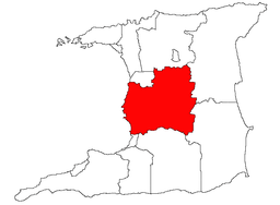 Location of Couva–Tabaquite–Talparo in Trinidad | |
Couva–Tabaquite–Talparo is one of the 9 regions of Trinidad and Tobago, and one of the five regions which form Gulf of Paria coastline on Trinidad's West Coast. Its regional capital and commercial center is Couva. Couva–Tabaquite–Talparo is the third-largest of Trinidad and Tobago's 9 regions, with an area of 723 square kilometres (300 sq mi). As of 2011, the population was 178,410. The region is the second-most populous and fourth-least-densely populated region in Trinidad with 247 inhabitants per square kilometre (640/sq mi).
Couva–Tabaquite–Talparo is bordered by the Gulf of Paria to the west, the Borough of Chaguanas to the north-west, Tunapuna–Piarco region to the north, Sangre Grande and Rio Claro–Mayaro to the east, Princes Town to the south and the City of San Fernando to the south-west. The region is directly adjacent to the Venezuelan state of Monagas to west separated by the Gulf of Paria.
Geography
Couva–Tabaquite–Talparo is Trinidad and Tobago's third largest region in area after Sangre Grande and Rio Claro–Mayaro. The region is situated in Central Trinidad within the Caroni Plains bordering the Gulf of Paria to west. It was a major region for sugar and cocoa production in the 18th and 19th centuries and the first half of the 20th century. The region features the Caroni–Arena Dam which supplies water to the northern regions of Trinidad and Navet Dam which supplies water to much of Central and Southern regions Trinidad. Much of the Central Range lies in the region which is home to the Brasso Venado and Gran Couva Waterfall. Couva–Tabaquite–Talparo also houses the Pointe-à-Pierre Wild Fowl Trust in Pointe-à-Pierre.
Wildlife
The Point-a-Pierre Wild Fowl Trust is located on the compound of a major petrochemical and oil refinery in south Trinidad. Encompassing two lakes and about 30 hectares of land the Trust is a popular destination for scientists and researchers. The Trust is the only eco-tourism site on the island with a boardwalk built along much of the first pond where there is also a small Amerindian museum. Point-a-Pierre Wild Fowl Trust is a wetland habitat that is home to locally endangered wetland birds. With over 26 hectares, there are about 90 bird species, including endangered waterfowl, songbirds, scarlet ibis, herons and other wading birds.
Demographics
Population
The Trinidad and Tobago Central Statistical Office reported the population of Couva–Tabaquite–Talparo was 178,410 on January 9, 2011, a 0.9% increase since the 2000 Census.[1] The population of Couva–Tabaquite–Talparo in the 2000 census was 162,779.
Ancestry
| Racial composition | 2011 |
|---|---|
| South Asian (Indo-Trinidadian) | 57.65% |
| Black (Afro-Trinidadian/Tobagonian) | 18.94% |
| Multiracial | 10.7% |
| Dougla (South Asian and Black) | 7.3% |
| West Asian (Chinese) | 0.16% |
| Native American (Amerindian) | 0.6% |
| Arab (Syrian/Lebanese) | 0.1% |
| White Trinidadian | 0.12% |
| Other | 0.8% |
| Not stated | 4.8% |
Urban Centers and Towns
| Rank | County | Pop. | |||||||
|---|---|---|---|---|---|---|---|---|---|
 Couva |
1 | Couva | Caroni | 45,362 | |||||
| 2 | Gasparillo | Victoria | 16,426 | ||||||
| 3 | Claxton Bay | Victoria | 14,436 | ||||||
| 4 | Freeport | Caroni | 11,256 | ||||||
| 5 | Carapichaima | Caroni | 4,465 | ||||||
| 6 | Chase Village | Caroni | 4,014 | ||||||
| 7 | Tabaquite | Saint George | 3,138 | ||||||
| 8 | Caparo | Caroni | 2,979 | ||||||
| 9 | St. Mary's | Caroni | 2,240 | ||||||
| 10 | Talparo | Saint George | 1,661 | ||||||
Electoral Districts
Electoral Districts within Couva–Tabaquite–Talparo Regional Corporation include:
- Balmain / Esperanza / Forres Park
- Caratal / Tortuga
- Claxton Bay / Pointe-a-Pierre
- Edinburgh / Chickland
- Felicity / Calcutta / Mc. Bean
- Preysal/Freeport / Calcutta
- Gasparillo / Bonne Aventure
- Las Lomas / San Rafael / Talparo
- Longdenville / Mamoral
- Perseverance / St. Mary's / Waterloo
- Piparo / San Pedro / Tabaquite
References
- Local Government Corporations, from Nalis, the National Library and Information Service of Trinidad and Tobago.
External links
Local Government in Trinidad and Tobago | ||
|---|---|---|
| Regional corporations |  | |
| Borough and city corporations | ||
| Other bodies | ||
| Counties (historic) | ||