Río Amazonas Airport
| Río Amazonas Airport | |||||||||||
|---|---|---|---|---|---|---|---|---|---|---|---|
 | |||||||||||
| Summary | |||||||||||
| Airport type | Public | ||||||||||
| Owner | Ecuadorian Military | ||||||||||
| Operator | Mission Aviation Fellowship | ||||||||||
| Location | Shell Mera, Ecuador | ||||||||||
| Elevation AMSL | 3,465 ft / 1,056 m | ||||||||||
| Coordinates | 01°30′19″S 78°03′46″W / 1.50528°S 78.06278°W | ||||||||||
| Map | |||||||||||
 PTZ Location of the airport in Ecuador | |||||||||||
| Runways | |||||||||||
| |||||||||||
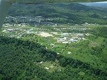
Río Amazonas Airport (IATA: PTZ, ICAO: SESM) is an airport serving Shell Mera, a town in the Pastaza Province of Ecuador. The airport was established in 1937 by Royal Dutch Shell and abandoned in 1948. In 1949 the Mission Aviation Fellowship, a Christian missionary group, established themselves in the area and used the airport as their main base.
The Pastaza VOR-DME (Ident: PAV) is located 0.91 nautical miles (1.69 km) off the approach threshold of Runway 30. The Pastaza non-directional beacon (Ident: PTZ) is located 0.78 nautical miles (1.44 km) off the same runway.[3][4]
Accidents and incidents
In March 2016, a military plane taking off from Amazonas Airport crashed in Pastaza province, killing all 22 soldiers aboard.[5][6][7]
See also


- Transport in Ecuador
- List of airports in Ecuador
References
- ↑ Airport information for Río Amazonas at Great Circle Mapper.
- ↑ Google Maps - Río Amazonas
- ↑ Pastaza VOR
- ↑ Pastaza NDB
- ↑ "EL MUNDO - Diario Líder de Información en Bolivia - Evo expresa sus condolencias por la muerte de 22 militares en Ecuador". Periódico El Mundo. Retrieved 2016-03-22.
- ↑ UNIVERSO, EL. "Un avión con 22 personas se accidenta en Pastaza, no hay sobrevivientes". El Universo (in Spanish). Retrieved 2016-03-22.
- ↑ "Tragedia en Ecuador; 22 soldados fallecen en accidente de avión militar en la Amazonía | ANDES". www.andes.info.ec. Retrieved 2016-03-22.
External links
- OpenStreetMap - Río Amazonas
- OurAirports - Río Amazonas
- SkyVector - Río Amazonas
- Airport information for Río Amazonas Airport at World Aero Data. Data current as of October 2006.
- Accident history for Río Amazonas Airport at Aviation Safety Network
- Current weather for Río Amazonas Airport at NOAA/NWS
This article is issued from
Wikipedia.
The text is licensed under Creative Commons - Attribution - Sharealike.
Additional terms may apply for the media files.