Remutaka Forest Park
| Remutaka Forest Park | |
|---|---|
 Catchpool Valley | |
 Remutaka Forest Park | |
| Location | North Island, New Zealand |
| Nearest city | Lower Hutt |
| Coordinates | 41°22′S 175°00′E / 41.36°S 175°ECoordinates: 41°22′S 175°00′E / 41.36°S 175°E |
| Area | 19,661.2 hectares (48,584 acres) |
| Established | 1972 |
| Governing body | Department of Conservation |
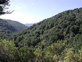
Remutaka Forest Park (spelled Rimutaka Forest Park prior to 2017) is a protected area near Wellington, New Zealand. Popular access points are south of Wainuiomata and in the upper Hutt Valley. The park covers 196.6 square kilometres (75.9 sq mi),[1] encompassing the Catchpool Valley and the Orongorongo Valley at the southern end of the Remutaka Range. Established in 1972, the park contains several short walks and five huts that can be booked and accessed by longer bush tramps.
A population of North Island brown kiwi has been established in the northern part of the Remutaka Forest Park, protected by a dog exclusion area.
In 2017, the name of the park (and range) was changed from "Rimutaka" to "Remutaka". (The former name continues to be used in some online documents.)
See also
References
- ↑ "Data Table - Protected Areas - LINZ Data Service". Land Information New Zealand. Retrieved 2017-10-18.
- Department of Conservation - Remutaka Forest Park information
- Rimutaka Forest Park Charitable Trust
| Wikimedia Commons has media related to Category:Remutaka Forest Park. |