Rifle River
| Rifle River | |
| River | |
| Country | United States |
|---|---|
| State | Michigan |
| Counties | Ogemaw, Arenac |
| Cities | Selkirk, Omer |
| Source | |
| - location | Ogemaw County, Michigan, United States |
| - coordinates | 44°23′58″N 84°01′57″W / 44.39944°N 84.03250°W |
| Mouth | Saginaw Bay |
| - location | Arenac County, Michigan, United States |
| - elevation | 577 ft (176 m) |
| - coordinates | 43°59′34″N 83°49′15″W / 43.99278°N 83.82083°WCoordinates: 43°59′34″N 83°49′15″W / 43.99278°N 83.82083°W |
| Length | 60 mi (97 km) |
| Basin | 385 sq mi (997 km2) |
| Discharge | for Saginaw Bay |
| - average | 181 cu ft/s (5 m3/s) |
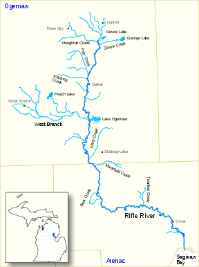 | |
Rifle River is a 60.3-mile-long (97.0 km)[1] river in the U.S. state of Michigan. It rises in northeastern Ogemaw County and flows through Arenac County to enter Saginaw Bay of Lake Huron.[2] Once a logging river during the Michigan forestry boom at the turn of the 20th century, the river is now primarily used for recreation, and is a state-designated natural river. It is a popular river for canoeing, with no portages or dams and an average depth of 18 inches, to 5 feet in downtown Omer. It is also known for having one of the best White Sucker (Catostomus commersonii) runs in the state of Michigan, in the spring.
.jpg)
Canoe liveries serving the Rifle River
Several private canoe operators provide equipment rental and transportation for river trips along the Rifle River.
- Whispering Pines Campground and Canoe Livery.[4]
Sterling, Michigan (Central portion of the Rifle River - Most Popular)
- River View Campground & Canoe Livery[5]
- Whites Campground & Canoe Livery[6]
- Rifle River Campground & Canoe Livery[7]
Omer, Michigan (Lower portion of the Rifle River)
- Russel's Canoe Liveryhttp://www.russellcanoe.com
- Riverbend Campground & Canoe Rental[8]
- Big Bend Campground & Canoe Rental[9]
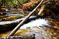 Springs form small creeks - like this one - that run into and feed the Rifle River.
See also
References
- ↑ U.S. Geological Survey. National Hydrography Dataset high-resolution flowline data. The National Map Archived 2012-04-05 at WebCite, accessed November 7, 2011
- ↑ "Rifle River". Geographic Names Information System. United States Geological Survey.
- ↑ Michigan State University Map Library
- ↑ http://www.michigan.org/property/whispering-pines-campground-and-canoe-livery/
- ↑ http://riverviewcampground.com
- ↑ http://whitescanoe.com
- ↑ http://riflerivercampground.com
- ↑ http://www.riverbendomer.com
- ↑ http://www.bigbendcamp.com
External links
| Wikimedia Commons has media related to Rifle River. |
| Authority control |
|---|