Ridge, Robertson County, Texas
| Ridge, Texas | |
|---|---|
| Unincorporated community | |
 Ridge, Texas  Ridge, Texas | |
| Coordinates: 31°08′44″N 96°19′19″W / 31.14556°N 96.32194°WCoordinates: 31°08′44″N 96°19′19″W / 31.14556°N 96.32194°W | |
| Country | United States |
| State | Texas |
| County | Robertson |
| Elevation | 358 ft (109 m) |
| Time zone | UTC-6 (Central (CST)) |
| • Summer (DST) | UTC-5 (CDT) |
| Area code(s) | 979 |
| GNIS feature ID | 1366443[1] |
Ridge is an unincorporated community in Robertson County, Texas, United States. It lies at an elevation of 358 feet (109 m), and it is located at 31°08′44″N 96°19′19″W / 31.14556°N 96.32194°W (31.1454605, -96.3219099).[2] Ridge is located along U.S. Route 79 and a Missouri Pacific Railroad line.
Ridge is part of the Bryan–College Station Metropolitan Statistical Area. Ridge's ZIP Code is 77856.[3]
Ridge was formed in the 1850s under the name Holly Springs as a community for nearby cotton farmers. In 1916, the Missouri Pacific Railroad placed a switch known as Ridge in the community, and the community became known as Ridge. Ridge's post office opened in 1926; the first postmaster was Robert Reeves.[4][5]
References
- ↑ "US Board on Geographic Names". United States Geological Survey. 2007-10-25. Retrieved 2008-01-31.
- ↑ U.S. Geological Survey Geographic Names Information System: Ridge, Robertson County, Texas
- ↑ USPS ZIP Code lookup tool Archived December 14, 2006, at the Wayback Machine.
- ↑ "Ridge, Texas". Handbook of Texas Online. Retrieved 3 July 2009.
- ↑ Wheat, Jim. Postmasters & Post Offices of Texas, 1846-1930. Retrieved July 3, 2009.
Municipalities and communities of Robertson County, Texas, United States | ||
|---|---|---|
| Cities | 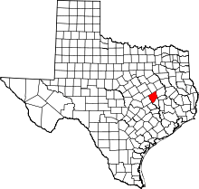 | |
| Unincorporated communities | ||
| Ghost town | ||
This article is issued from
Wikipedia.
The text is licensed under Creative Commons - Attribution - Sharealike.
Additional terms may apply for the media files.