Richard Toll
| Richard Toll | |
|---|---|
| Town | |
 | |
 Richard Toll | |
| Coordinates: 16°28′N 15°41′W / 16.467°N 15.683°W | |
| Country |
|
| Region | Saint-Louis |
| Department | Dagana |
| Population | |
| • Total | ~90,000 |
| Time zone | UTC+0 (GMT) |
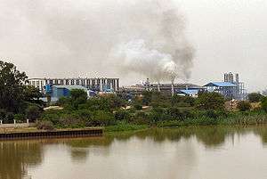
Richard Toll is a town in northern Senegal, lying on the south bank of the River Senegal, just east of Rosso. Originally a colonial town, it was named for the park of the Chateau de Baron Roger, laid out by botanist Jean Michel Claude Richard. A rice growing scheme was originally initiated by France's colonial development organisation, FIDES, in 1949 with an initial cultivated area of 6,000 hectares (14,830 acres). The town's main industry is sugar. Estimated population 2007: 70,000.
History
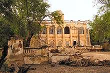
Until 1817 at roughly the location of Richard Toll there were two villages, Ndiangué and Xhouma, inhabited by the Mbodi people — descendants of Brack and followers of the royal Walo tradition. In 1817 the French government's seniormost representative in the region, Schmaltz, created an outpost community on the Senegal River, naming it l’Escale. In 1822, the new governor, Baron Roger, sent a botanist and nurseryman named Michelle Claude Richard to work in L’Escale and renamed it Richard’s Toll, with Toll being the word for Farm in Pulaar, a local language. At this time there were 28 residents, and 1148 nomadic workers living in Toll. It grew greatly in 1945 with the creation of the Mission Agricole du Sénégal, which also brought other institutions such as a hospital, and chapel, and a school. There was a rapid demographic growth in 1970 with the implementation of the Compagnie Sucriére Sénégalaise, 'Senegal Sugar Company', which brought in around 15,000 inhabitants and brought about two phenomenon: the joining of the local villages, and the creation of new neighborhoods. By 1980 Richard Toll had six neighborhoods: Escale, Ndaingué, Ndiaw, Khouma Wolof, Khouma Peul, and Ndombo Alarba. Since then the city has grown and evolved into what it is today, including the addition of neighborhoods such as Campement, Thiaback, GAE2, and Taouey.
Population and demography
The latest estimate of the population available at the mayors office with was from 2005 which was at 46,547, however more recent estimates have put it around 90,000.
The latest gender, and age breakdown the mayors office had was from 2006, which stated 77.79% of inhabitants were between the ages of 0 and 34, 20.71% were between the ages of 35 and 74, and 1.19% were over the age of 75. Women constituted 52.01% of the population, and men 47.99%.
Neighborhoods
Richard Toll currently comprises 12 quartiers: Ndiao, Ndiangué, Richard Toll Escale, Campement et Nourou, Thiabakh, Ndombo Alarba, Khouma Gallo Malick, Gae II, Khouma Yakh Sabar, and Khouma Mbodiéne/Khouma Thiaréne.
Markets
There are two markets in Toll, the Richard Toll market, and the Xhouma Market. The Richard Toll market is a little larger than the Xhouma market. It is located in the main part of the city, and encompasses about 3 square city blocks although it is hard to tell where the market ends, and the regular city begins. I would estimate that there are over 50 established stores, and stands in the market. The Xhouma market is located on the eastern side of town in a primarily Pulaar area. It is located off the main road, as opposed to the Richard Toll market which is in more of a city grid.
Economic activities
The main economic activities in Richard Toll are agriculture, fishing, animal husbandry, and commerce. Less popular economic activities are transportation, tourism, and artisanal goods. Richard Toll is most known for its sugar refinery, which is French owned and exports sugar to most of Senegal.
Popular culture
Marie Laforêt has a song about Richard Toll.[1]
References
External Links
- Yee, Amy (1 May 2018). "In a Corner of Senegal, a Victory Over Malaria". New York Times. Retrieved 2018-08-03.