Riaño, León
| Riaño | |||
|---|---|---|---|
| Municipality | |||
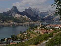 New Riaño, the new village built to replace the submerged Riaño. The old village is located under the bridge. The mountain on the left is Peak Gilbo. | |||
| |||
 Riaño Location in Spain | |||
| Coordinates: 42°58′29″N 5°00′43″W / 42.97472°N 5.01194°W | |||
| Country | Spain | ||
| Autonomous community | Castile and León | ||
| Province | León | ||
| Comarca | Montaña de Riaño | ||
| Government | |||
| • Mayor | Manuel Javier Fernández Presa | ||
| Area | |||
| • Total | 97.63 km2 (37.70 sq mi) | ||
| Elevation | 1,112 m (3,648 ft) | ||
| Population (2010) | |||
| • Total | 532 | ||
| • Density | 5.4/km2 (14/sq mi) | ||
| Demonym(s) | Riañéses | ||
| Time zone | UTC+1 (CET) | ||
| • Summer (DST) | UTC+2 (CEST) | ||
| Postal code | 24900 | ||
| Website | Official website | ||


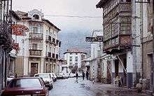
Old Riaño, before it was flooded, November 1984.
Riaño is a former small municipality located along the Esla River in the mountains of the province of León, in the autonomous community of Castile and León, northern Spain. The village was across the river from Peak Gilbo. Located 3650 feet above sea level, it is in the Cantabrian mountains near the foothills of the Picos de Europa.
Due to planned construction of a dam and reservoir in the 1980s, for flood control and generation of hydroelectric power, the village and its lowlying farmland were to be submerged, as were six other villages in the associated dam project. The residents were relocated to New Riaño, built as a replacement higher above the reservoir waters. [1] In 2010 the village had 532 residents.
Noted residents and natives
- Imanol Arias, film actor
See also
References
- ↑ Andy Simington, Northern Spain Handbook, (Footprint Travel Guides, 2003), 284.
External links
| Wikimedia Commons has media related to Riaño. |

This article is issued from
Wikipedia.
The text is licensed under Creative Commons - Attribution - Sharealike.
Additional terms may apply for the media files.