Rhodt unter Rietburg
| Rhodt unter Rietburg | ||
|---|---|---|
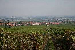 View on Rhodt from Weyher | ||
| ||
 Rhodt unter Rietburg Location of Rhodt unter Rietburg within Südliche Weinstraße district 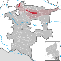 | ||
| Coordinates: 49°16′22″N 8°06′29″E / 49.27278°N 8.10806°ECoordinates: 49°16′22″N 8°06′29″E / 49.27278°N 8.10806°E | ||
| Country | Germany | |
| State | Rhineland-Palatinate | |
| District | Südliche Weinstraße | |
| Municipal assoc. | Edenkoben | |
| Government | ||
| • Mayor | Torsten Engel (CDU) | |
| Area | ||
| • Total | 10.06 km2 (3.88 sq mi) | |
| Elevation | 206 m (676 ft) | |
| Population (2017-12-31)[1] | ||
| • Total | 1,194 | |
| • Density | 120/km2 (310/sq mi) | |
| Time zone | CET/CEST (UTC+1/+2) | |
| Postal codes | 76835 | |
| Dialling codes | 06323 | |
| Vehicle registration | SÜW | |
| Website | www.rhodt.de | |

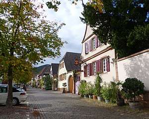
The Theresienstrasse is the most famous street of Rhodt unter Rietburg
Rhodt unter Rietburg is a municipality in Südliche Weinstraße district, in Rhineland-Palatinate, western Germany. Rietburg castle (ruins) is located on a nearby hill. The village has been making wine for over 1200 years, and is one of the centres of Palatine wine as a home of Rietburg wine co-operative.
See also
| Wikimedia Commons has media related to Rhodt unter Rietburg. |
References
- ↑ Statistisches Landesamt Rheinland-Pfalz "Bevölkerungsstand 2017 - Gemeindeebene" Check
|url=value (help). Statistisches Landesamt Rheinland-Pfalz (in German). 2018.
This article is issued from
Wikipedia.
The text is licensed under Creative Commons - Attribution - Sharealike.
Additional terms may apply for the media files.