Rheinsberg
| Rheinsberg | ||
|---|---|---|
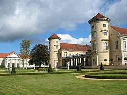 Rheinsberg Castle | ||
| ||
 Rheinsberg Location of Rheinsberg within Ostprignitz-Ruppin district 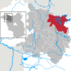 | ||
| Coordinates: 53°5′54″N 12°53′45″E / 53.09833°N 12.89583°ECoordinates: 53°5′54″N 12°53′45″E / 53.09833°N 12.89583°E | ||
| Country | Germany | |
| State | Brandenburg | |
| District | Ostprignitz-Ruppin | |
| Government | ||
| • Mayor | Frank-Rudi Schwochow | |
| Area | ||
| • Total | 324.83 km2 (125.42 sq mi) | |
| Elevation | 61 m (200 ft) | |
| Population (2017-12-31)[1] | ||
| • Total | 8,111 | |
| • Density | 25/km2 (65/sq mi) | |
| Time zone | CET/CEST (UTC+1/+2) | |
| Postal codes | 16831 | |
| Dialling codes | 033931 | |
| Vehicle registration | OPR | |
| Website | www.rheinsberg.de | |


Rheinsberg is a town and a municipality in the Ostprignitz-Ruppin district, in Brandenburg, Germany. It is situated on the river Rhin, approx. 20 km north-east of Neuruppin and 75 km north-west of Berlin.
History
Frederick the Great, while still Crown Prince, designed and moved into a restored chateau in Rheinsberg shortly after his 1733 marriage to Elisabeth Christine of Brunswick-Bevern. Here he experienced his "Rheinsberg Period", an era marked by regular correspondence with Voltaire, boisterous celebration in the company of minor philosophers and musicians, and the writing of several works of political theory, including the Anti-Machiavel.[2]
In 1870, the painter Eduard Gaertner and his family decided to leave the hectic atmosphere of Berlin and settle in Flecken Zechlin, a suburb of Rheinsberg - where he lived until his death in 1877.
Demography
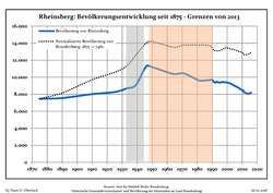 Development of population since 1875 within the current Boundaries (Blue Line: Population; Dotted Line: Comparison to Population development in Brandenburg state; Grey Background: Time of Nazi Germany; Red Background: Time of communist East Germany)
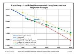 Recent Population Development and Projections (Population Development before Census 2011 (blue line); Recent Population Development according to the Census in Germany in 2011 (blue bordered line); Projection by the Brandenburg state for 2005-2030 (yellow line); Projection by the Brandenburg state for 2014-2030 (red line); Projection by the Bertelsmann Foundation for 2012-2030 (green line)
| Rheinsberg: Population development within the current boundaries (2017)[3] | ||||||||||||||||||||||||||||||||||||||||||||||||||||||||||||||||||||||||||||||||||||||||||||||||||||||||||||||||||||||||||||||||||||||
|---|---|---|---|---|---|---|---|---|---|---|---|---|---|---|---|---|---|---|---|---|---|---|---|---|---|---|---|---|---|---|---|---|---|---|---|---|---|---|---|---|---|---|---|---|---|---|---|---|---|---|---|---|---|---|---|---|---|---|---|---|---|---|---|---|---|---|---|---|---|---|---|---|---|---|---|---|---|---|---|---|---|---|---|---|---|---|---|---|---|---|---|---|---|---|---|---|---|---|---|---|---|---|---|---|---|---|---|---|---|---|---|---|---|---|---|---|---|---|---|---|---|---|---|---|---|---|---|---|---|---|---|---|---|---|
|
|
| ||||||||||||||||||||||||||||||||||||||||||||||||||||||||||||||||||||||||||||||||||||||||||||||||||||||||||||||||||||||||||||||||||||
Geography
Lakes
Photogallery
 Monument opposite castle
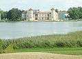 Castle seen from monument place
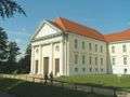 Concerthall (part of the castle)
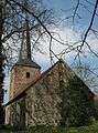 Church in Dierberg
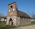 Fire engine house in Heinrichsdorf
Twin towns

References
- ↑ "Bevölkerung im Land Brandenburg nach amtsfreien Gemeinden, Ämtern und Gemeinden 31. Dezember 2017 (Fortgeschriebene amtliche Einwohnerzahlen auf Grundlage des Zensus 2011)". Amt für Statistik Berlin-Brandenburg (in German). 2018.
- ↑ MacDonogh, Giles (1999). Frederick the Great: A Life in Deed and Letters. New York: St. Martin's Griffin. pp. 98–129. ISBN 0-312-27266-9.
- ↑ Detailed data sources are to be found in the Wikimedia Commons.Population Projection Brandenburg at Wikimedia Commons
External links
- Official website

Towns and municipalities in Ostprignitz-Ruppin | ||
|---|---|---|