Reynier Village, Los Angeles
| Reynier Village, Los Angeles | |
|---|---|
| Neighborhood of Los Angeles | |
 "Welcome to Reynier Village" sign located at the intersection of Cadillac & Shenandoah. | |
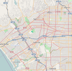 Reynier Village, Los Angeles Location within Western Los Angeles | |
| Coordinates: 34°02′24″N 118°23′05″W / 34.0400406°N 118.3847449°WCoordinates: 34°02′24″N 118°23′05″W / 34.0400406°N 118.3847449°W | |
| Country |
|
| State |
|
| County |
|
| Time zone | Pacific |
| Zip Code | 90034 |
| Area code(s) | 310 |
Reynier Village is a neighborhood on the Westside of Los Angeles, California.
Geography
Reynier Village is a triangular-shaped neighborhood bordered on the north by Cadillac Avenue; on the west by Robertson Boulevard; and on the southeast by Kramerwood Place, the 10 Freeway, and Garth Avenue.[1][2]
Reynier Village is south of La Cienega Heights and southwest of Faircrest Heights.
The Los Angeles Times' Mapping L.A. project places Reynier Village is in the larger neighborhood of Mid-City.[3] However, according to the Reynier Village neighborhood association, the village is in Zone 5 of the South Robertson neighborhood.[2][4]
History
According to locals, the subdivision was named after a family whose home stood on what it now the city-maintained Reynier Park.[2]
A well-preserved 1 1/2 -story adobe in the heart of this small West Los Angeles neighborhood speaks to its early days as part of the Rancho Rincon de los Bueyes (which means "corner of the oxen"). Built in 1865 by Antonio Jose Rocha II, the privately occupied residence at 2400 Shenandoah St. in 1963 became Los Angeles' 13th historic-cultural monument.[2]
Rocha House, the 13th Los Angeles Historic-Cultural Monument, is located in the village.[5]
For many years, real estate agents had called the area "Beverlywood adjacent" or "south Robertson" (the name of the neighborhood council, which encompasses several neighborhoods including Reynier Village).[2]
Parks and recreation
- Reynier Park - 2803 Reynier Avenue
Facility Features include: Barbecue Pits, Basketball Courts (Lighted / Outdoor), Childrens Play Area and Picnic Tables.[6]
Notes and references
- ↑ "Reynier Village Neighborhood Association Map". Retrieved 3 July 2018.
- 1 2 3 4 5 Spanish style still defines central pocket by Martha Groves (Los Angeles Times, 26 February 2006)
- ↑ Location of Reynier Village on Mapping L.A., Los Angeles Times
- ↑ Reynier Village Neighborhood Association
- ↑ Reynier Village by Yosuke Kitazawa (KCET, 10 September 2012)
- ↑ http://www.laparks.org/park/reynier
| By topic |  | |
|---|---|---|
| Government | ||