Rettenegg
| Rettenegg | |
|---|---|
 Rettenegg Location within Austria
Location within Weiz district
| |
| Coordinates: 47°31′33″N 15°46′49″E / 47.52583°N 15.78028°ECoordinates: 47°31′33″N 15°46′49″E / 47.52583°N 15.78028°E | |
| Country | Austria |
| State | Styria |
| District | Weiz |
| Government | |
| • Mayor | Johann Ziegerhofer (ÖVP) |
| Area | |
| • Total | 78.87 km2 (30.45 sq mi) |
| Elevation | 862 m (2,828 ft) |
| Population (1 January 2016)[1] | |
| • Total | 754 |
| • Density | 9.6/km2 (25/sq mi) |
| Time zone | UTC+1 (CET) |
| • Summer (DST) | UTC+2 (CEST) |
| Postal code | 8674 |
| Area code | 03173 |
| Vehicle registration | WZ |
| Website | www.rettenegg.at |
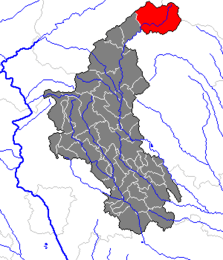
Rettenegg is a municipality in the district of Weiz in the Austrian state of Styria.
Geography
Rettenegg lies in the Fischbach Alps at the confluence of the Pfaffenbach and the Feistritz.
References
This article is issued from
Wikipedia.
The text is licensed under Creative Commons - Attribution - Sharealike.
Additional terms may apply for the media files.