Resolute Mountain
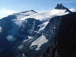 resolute mountain from the north
| Resolute Mountain | |
|---|---|
|
| |
| Highest point | |
| Elevation | 3,150 m (10,330 ft) |
| Prominence | 395 m (1,296 ft) |
| Coordinates | 52°4′24″N 116°39′34″W / 52.07333°N 116.65944°WCoordinates: 52°4′24″N 116°39′34″W / 52.07333°N 116.65944°W |
| Geography | |
 Resolute Mountain Alberta, Canada | |
| Location | Alberta, Canada |
| Parent range | Cline Range[1] |
| Topo map | NTS 83C/02 |
Resolute Mountain is located in David Thompson Country, western Alberta, Canada, 12 km north of Saskatchewan River Crossing. Its line parent is Mount Cline located 2 kilometers to the east.[2][3]
Resolute has two main peaks, Lion and Lioness. They are each about 3150 m high. Both peaks are glaciated on their northern slopes.[4] Resolute was first ascended in 1958 by A. Hober and E. Hopkins. The easiest route up Resolute is accessible from Alberta Highway 11, where it crosses Thompson creek.[5]
References
- ↑ "Cline Range". Peakbagger.com. Retrieved 2017-08-12.
- ↑ "Environmentally Significant Areas Inventory of the Rocky Mountain Natural Region of Alberta" (PDF). p. 36.
- ↑ "Resolute Mountain". peakery.com. Retrieved 2017-08-13.
- ↑ "Peaks of the Canadian Rockies". peakfinder.com. Retrieved 2017-08-13.
- ↑ Ross, Jane; Kyba, Daniel (2016-03-02). The David Thompson Highway Hiking Guide – 2nd Edition. Rocky Mountain Books Ltd. ISBN 9781771600910.
This article is issued from
Wikipedia.
The text is licensed under Creative Commons - Attribution - Sharealike.
Additional terms may apply for the media files.