Republican Seismic Survey Center of Azerbaijan National Academy of Sciences
|
| |
| Founded | September 01, 1998 |
|---|---|
| Headquarters | Baku, Azerbaijan |
Key people | Gurban Yetirmishli (General Director) |
| Website | www.seismology.az |
Republican Seismic Survey Center is the main organization, involved in the research and study of earthquakes on the territory of Azerbaijan Republic. Seismological, geophysical, geochemical and geodynamic complex researches are conducted in the Center.
RSSC is the only organization in CIS, where the seismological researches are conducted by a network of seismic stations operating via satellite communication. It should be noted that, this Seismic Stations Network produced by “Kinemetrix” company of USA, is widely used by the main leading countries of the world.
Now, there are 35 seismic stations of RSSC operating via satellite communication on the territory of Republic. Five more seismic stations will be installed on land. The installation of 3 seabed seismic stations is planned in Azerbaijani sector of Caspian Sea for the first time in CIS. As the result of the installation of these stations, it will be possible to research perfectly, both the tectonic processes in the sea, and the impacts of these processes to oil fields and oil production.
History
The history of the Republican Seismic Survey Center (RSSC) of Azerbaijan National Academy of Sciences (ANAS) has various historic stages. In Azerbaijan, the first instrumental observations began in the early XX century.
In 1902, after a strong earthquake which occurred in Shamakhi, first supervision began with the initiative of Nobel brothers to establish 3 seismic stations, thereby the instrumental observations have been started.
The independent Seismological Service of Azerbaijan was restricted by the former Soviet Union for a long time. By the decision of the Council of Ministers of Azerbaijan Soviet Socialist Republic in 1979 according to the decree of the National Academy of Sciences was created ”Geophysics” Geophysical Research Party at the Institute of Geology of ANAS.
In 1980 on its basis was founded Experimental Methodical Geophysics Expedition. The expedition was supervised by Arif Hasanov, the corresponding member of ANAS,doctor of geology-mineralogy sciences.
In 1980 -1990- years was founded the network of stationary geochemical-geophysical stations covered all of the seismogenic zone of the republic.Hydro-gas and radio - chemical industries began the study of the assessment of stress in the seismogenic zone of deformation,were developed geochemical and geophysical field methods to identify the signs of abnormal changes in the parameters of the seismic prognosis.
By the decisions of Cabinet of Ministers of Azerbaijan Republic 179 dated; 01.09. 1998. and Presidium of Azerbaijan National Academy of Sciences (ANAS) N22/2 dated 17.12.1998. EMGE was given the status of Republican Seismic Survey Center (RSSC) of ANAS in 1999 .
Since 2008, the corresponding member of ANAS, “Honoured Scientist”, the doctor of geology-mineralogy sciences, Yetirmishli Gurban Jalal headed the RSSC. There was his exceptional services in the establishment and expansion of seismic monitoring network .
The data gathered on the basis of the researches , conducted at the Republican Seismic Survey Center, is used not only for the aim of manufacturing, but also in research studies.
The Center, cooperates with the seismology centers of more than 20 foreign country. The RSSC is a member of five main international seismological organizations: IRIS (Intercorporated Research Institutions for Seismology), ORFEUS (Observatories and Research Facilities for European Seismology), AGU (American Geophysical Union), EMSC (European – Mediterranean Seismological Center), ESC (European Seismological Commission).
Seismic researches based on observation network which consisting of 35 telemetry seismic stations. Investigating seismicity in the territory of Republic, kinematic and dynamic parameters of earthquakes, seismic regime, the patterns of earthquakes distribution. Carrying out seismic studies of the dynamics processes in the focal areas, the definition of the active parts in the deep faults and assessment the maximum possible intensity of earthquakes. Design velocity model, studies of seismic tomography, study of the earthquakes mechanism, seismic risk assessment in big cities, works on seismic zoning, and study of seismicity in major construction projects.
Are engaged in display of seismoabnormal structures effects in geophysical areas and complex researches. Investigate geomagnetic intensity of a field through a network of geophysical stations, gravity and variations of gravitational potential of the second derivative.
Are engaged in display of seismoabnormal structures effects in geochemical areas. The analysis hydro-gas and radiochemical components in geochemical seismoactive regions of the country. These researches allow estimating the deformed-tension seismogene zones and allow finding out abnormal effects before earthquakes in seismogene areas.
Is studying the seismicity of the territories of the Republic, investigating the kinematical, and dynamical parameters of the earthquakes.
The seismological investigations are being done by the observational network consisting of 31 telemetric stations is calculating the seismicity regime of republican territories, the of formula of distribution of earthquake epicenters, investigating the formula dynamics of seismic processes in the center zones, defining the depth faults of active parts. And valuating the intensity of maximum strong earthquakes in these zones. The bureau is studying the mechanism of the strong earthquakes, valuated the seismic risk of the big cities, is investigating the seismicity of the huge construction object’s area. In 2003 Republicans center of the Seismological services ANAS has started the renovation of Seismic monitoring system in the territory of the Azerbaijan. The telemetric products purchased from USA “kinemetrics” company, are conducting a seismological monitoring in the regions.
Earthquake Research Bureau is engaged in the interpretation of earthquakes recordings by the seismic stations of the republic and the determination of their kinematic and dynamic parameters.
After the strong Caspian (Baku) earthquake occurred on 25 November 2000, adopted a decree of the National Leader Heydar Aliyev on Azerbaijan seismic network equipment with the most modern appliances.
In 2003, on the territory of Azerbaijan were installed 14 digital seismic stations of “Kinemetrics” company, which recorded local, near, distant earthquakes to 3 seconds precision through the satellite communication in real time. The registration and processing of seismic data was carried out through the system “Antelope 4.3”.
Since 2009, the seismic network of Azerbaijan expanded and now 35 seismic stations located on the territory of Azerbaijan. Each seismic station is equipped with the most modern devices:
a) Datalogger Quanterra- Q330;
b) A three-component of broadband seismometers STS-2.5;
c) Force Balance Accelerometers EpiSensor ES-T;
d) Ultra-Low Power Field Data Acquisition Marmot.
Now, the registration and processing of earthquakes conducted through the program “Antelope 5.2-64” with 7 computer (Quard Core İntel Xeon) in the system of MAC OSX 10.64.
Availability of interactive communication in real mode enables to control the technical condition of equipment of seismic stations which located in different points of the country, their temperature and other issues.
All information is registered from seismic stations by satellite enters the Earthquake Research Bureau in Baku.
In Earthquake Research Bureau data using 35 telemetry stations are processed local, near and distant earthquakes. As a result of the interpretation, all defines the parameters of all foci registered earthquakes epicenters. (Tₒ, φ, λ, H and ml). According to the processing of local and near earthquakes compiled earthquake catalog of Azerbaijan and adjacent areas.
In order to detect warning signs of earthquakes is carried out to investigate change of speed of propagation of seismic waves ratio parameter (τ)
Is studied characteristics of seismogenic areas calculated the dynamic parameters of earthquakes, spectral analysis, as well as built map of epicenters, map activity, the histogram of the energy distribution and the number of earthquakes, histogram depth, velocity models. Studied and researched the scientific basis of mechanisms of earthquakes felt on the territory of the Republic and the intensity J0=3-4 points at the epicenter and investigated the scientific basis.
By the center in Azerbaijani sector of the Caspian sea is continuing to install 3 offshore seismic stations (Umid, Bahar, Guneshli).
Macroseismic studies are one of the main parts of seismological research, and are based on a study of earthquakes effects on the surface of the earth. These studies provide an opportunity to define the contours of sections with different estimates of the intensities, to express an opinion about the parameters of the earthquake and the structure of surrounding.
Macroseismic studies are particularly important in the engineering and seismological studies and microseismic zoning.
Processing of materials collected from macroseismic observations are carried out on the basis of an assessment of the seismic effect on both quantitative and qualitative methods.
Performing macroseismic studies consist of definition of earthquakes` macroseismic intensity.
To characterize the strength of the earthquake on the MSK-64 scale different signs are used: the extent of damage of buildings and structures, residual deformations in the soil, ground water regime changes, perceptibility concussion and etc.
Macroseismic concussion analysis of the material makes it possible to estimate the intensity on a scale. As a result, constructed a schematic map of isolines is build and it reflects the geographical distribution of macroseismic implications. Subsequently, the results of macroseismic studies to determine the source parameters: its coordinates, depth, magnitude, direction, length, geometric parameters.
To achieve the desired volume and density of macroseismic studies you need to use three main methods of macroseismic studies:
- Survey on the spot (with J ≥ VI);
- Conducting a survey (with little perceptible earthquakes);
- Distribution of questionnaires (in II ≤ J ≤ VI).
The plan of the macroseismic department consists of the following work:
1. Analysis of macroseismic area and source parameters of historical earthquakes in Azerbaijan.
2. Conducting visual observations on the buildings and terrain to assess the effects of earthquakes, conducting public surveys.
3. Defining the parameters of the earthquake.
4. Construction of graphs, tables, diagrams and maps.
5. Periodic publication of scientific articles.
6. Preparation of annual reports.
Head director
Head director
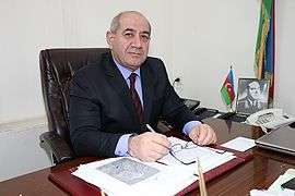
Gurban Jalal oglu Yetirmisli - was born in 4 September 1952 year.
In 1974, was graduated from Azerbaijan State University (BSU), faculty of geology.
From 1980 to 2008, was Deputy General Director of RCSS ANAS. Since 2008, is general director of the Republic Seismic Survey Center. He was elected a corresponding member of ANAS in 2014. Held a number of scientific researches in geodynamics, in difficult conditions of seismic active zones, evaluation of deep layers of oil and the prospects of Lower Kura depression, author 122 scientific articles. A number of articles have been published in prestigious scientific journals of the world.
In 2000 he defended his thesis on the topic "The distribution of oil and gas fields in the seismic-geodynamic conditions of Lower Kura Depression."
In 2010, successfully defended his doctoral thesis on the topic "Seismicity of the South Caspian depression" and received the degree of Doctor in Geological and Mineralogical Sciences.
Made a unique contribution in expanding the network of telemetry seismic stations of the Republican Seismological Service, in cooperation with ANAS, increased the number of seismic satellite stations from 14 to 35, and has provided the center with programs in accordance with international standards and improved the work to a high standard.
Co-author of the book "The volume of Geophysics", the author of the book "Review of the method of zoning the stress-strain factors on the territory of Azerbaijan", Chief Editor of the scientific journal "Seismoprognosis monitoring in Azerbaijan."
Under the guidance of G. Yetirmishli, two young Geology and Mineralogy employees, defended the degree of PhD. Currently, about 10 doctoral students and candidates continue the researches in scientific fields under his leadership.
Is a member of the editorial board of ANAS journal "Heberler" (a series of Earth Sciences.)
Chairman of the Scientific and Technical Council of the National Academy of Sciences of RCSS, and a member of the European Seismological Commission.
Was awarded with "Honorary Order" of the National Academy of Sciences on the occasion of the 50th anniversary in 2003.
In 2005, by order of the President of Azerbaijan Republic was awarded with medal "Tereggi"
President of Seismologists Association.
Action
Under the direction of scientific research of Republican Seismic Survey Center of Azerbaijan National Academy of Sciences is included: The study of earthquakes kinematic and dynamic parameters of seismicity on the territory of the Republic. The complex research of geophysical and geochemical siesmo abnormal effects evidence in the structures and properties. Geodynamic investigations (GPS);
In the center of Seismic surveys consisting of 35 telemetry seismic stations, based on the observation networks, explored the republic\'s territory seismic regime, the distribution of earthquake epicenters legitimacy, fire zones seismic processes dynamics, identified the active parts of the deep breaks and estimated these areas powerful earthquake’s maximum intensity. Studied the mechanism of earthquake epicenters, estimating big cities seismic risk, exploration of large building projects areas seismicity.
Studied gravity and gravitational potential variations of the second derivative through a network of geophysical and geochemical stations of geomagnetic field.
Analysing of the Republic seismically active regions hydro-geochemical field, and hydro-gas-and radio-chemical components. The seismogenic zone of deformation – estimation of tension situation and seismogenic areas assess of Ml>4.0 earthquake which enables anomalous effects.
Seismology
Is studying the seismicity of the territories of the Republic, investigating the kinematical, and dynamical parameters of the earthquakes.
The seismological investigations are being done by the observational network consisting of 31 telemetric stations is calculating the seismicity regime of republican territories, the of formula of distribution of earthquake epicenters, investigating the formula dynamics of seismic processes in the center zones, defining the depth faults of active parts. And valuating the intensity of maximum strong earthquakes in these zones. The bureau is studying the mechanism of the strong earthquakes, valuated the seismic risk of the big cities, is investigating the seismicity of the huge construction object’s area. In 2003 Republicans center of the Seismological services ANAS has started the renovation of Seismic monitoring system in the territory of the Azerbaijan. The telemetric products purchased from USA “kinemetrics” company, are conducting a seismological monitoring in the regions.
Operations and research
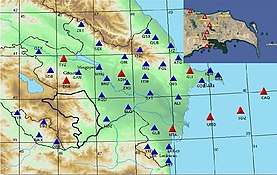
.jpg)
The center researches earthquakes in Azerbaijan and the abnormal geophysical, geochemical and geodynamic seismic effects preceding them with a geographic information system (GIS). It consists of 35 telemetric seismic stations and 22 GIS stations, one of which is at a depth of 8,324 metres (27,310 ft). With these stations, the RSSC researches the dynamics of seismic processes, identifies the active portions of deep faults and estimates maximum earthquake intensity, the mechanism of earthquake epicenters, the seismic risk to large cities and the seismicity of large construction projects. Gravity, potential gravitational variations and Earth's magnetic field are studied with a network of geophysical and geochemical stations.
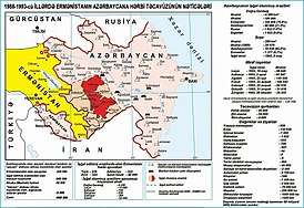
As a result of the Nagorno-Karabakh War and the subsequent capture of Nagorno-Karabakh and its surrounding area, the RSSC seismic station in Kalbajar (opened in 1984) was destroyed on 1 February 1992; stations in Aghdam and Jabrayil, opened in 1981, were destroyed on 1 June 1993. The stations are planned to be rebuilt if the Azerbaijani government can recapture the region. New seismic stations have been set up in Aghdam and Fuzuli on Azerbaijani territory.
The RSSC began renovating its seismic monitoring system in 2003, and three seismic seabed stations will be set up in the Azerbaijani sector of the Caspian Sea for the first time. These stations will allow advanced research of seabed tectonic processes and their effects on oil fields and oil production.
During an earthquake
Behaviour during earthquake
During earthquake, trembling cause in people, the fear, nervousness and creates pressure. Thus, for the first time of earthquakes, people should try to be quiet and constrained.
Following rules are necessary for observing to protect yourself during earthquake.
1.If you feel, building or ground trembling, do not react nervously (Shouts of fear which can affect actions, psychology of other people etc.) 2.If you indoors lay down under a table or a bed. If doors are opened, stand under a doorway or in a corner inside a room. Do not forget that at jolting first of all burst and break external walls of buildings. Therefore to run or hide under a window is forbidden. 3.During earthquake is forbidden to stand near to large things (A refrigerator, furniture etc.). These things can fall on you. 4.During earthquake is forbidden to run out from a building or to leave on a ladder. It is dangerous! Ladders can collapse. 5.If you live in a high-rise building, during earthquake do not run to the lift or ladders. Stand under a doorway or in a corner inside a room and wait, until the shaking stops. 6.During earthquake do not jump out of windows. It can lead to injuries and heavy damages. 7.During earthquake if you in a public place, do not run to crowd, find a safe place. If it is possible, hide children in a safe place. 8.During earthquake if you are near to a high-rise building, do not run to it. 9.During earthquake if you are in the car, do not stop on the bridge or near a high-rise building. 10.During earthquake if you are, in a two-storied brick building or in a building with the weak base try to leave this building immediately. 11.Do not forget during an earthquake you may feel some aftershocks. So try not to lose self-control till the end of aftershocks. 12.The earthquake lasts seconds. After trembling pay attention to receptions of injuries at yourself and at associates. If there are injuries, render the first medical aid. 13.Earthquake can occur at any time, therefore in advance find safe places from the house and a building where do you live. 14.Find a safe place at home in advance, (corners, doors, etc.) and keep this in mind in a furniture arrangement. 15.At uselessness switch -off gas, an electricity and water in apartment. 16.If possible, do not hold heavy items on the shelves, and fix to the walls a bookshelves. 17.For first-aid, keep in readiness a bag with the necessary medicines. 18.Arrange a bed far away from heavy furniture and large windows. 19.By a call of the help in emergency situations, write down in advance all telephone numbers of state structures in a notebook.
Who possesses the following telephone numbers:> 1.Rescue Services of the Ministry of Emergency Situations of the Republic of Azerbaijan – 112> 2.Ministry of Internal Affairs – 102> 3.First-aid - 103>
Classification of earthquakes
Starting from the earlier years of the human history generally to evaluate the intensity of the earthquakes is used to observe them according their effects to the environment (destruction, damages)
But generally, in these comparison there were many subjective factors based on the human feelings.
The strength of the earthquakes is changing according to its distance. In XİX century there were attempts to classify earthquakes according to their damages to our lives, geological environment and etc. At the end of that century there was widely spread the Rossi- Forel (RF) earthquake intensity scale. In these scale the earthquakes intensity is divided to ten points.
In 1902 in Italy by the Juzeppe Merkali has been adopted the scale of 12 points. In 1931 the American scientists Q. Vud. And F. Nyumen and in 1956 the Richter has made a few changes in that scale. And now this scale is called modified Merkalli and Richter scale (MMI)
From the 1964 the in Europe and in Ex Soviet Union where Azerbaijan was one of the members has been accepted the 12 unit European MSK Scale. The name of the scale was composed from the capital letter of its founders. S.V. Medvedev (USSR) V. SHponkhoyer, (GDR) and Karnik. (Chekoslovakia) There is an additional 12 points European Macroseismic (EMS) scale except MMI And MSK scales. And also there is a scale of Japanese Meterological Agency (JMA) with 7 unit scale is existing.
The following 12 points seismic intensity scale is given above.
1 points- hardly felt
2-points- hardly felt. IS felt by the people in the constant position
3- points Weak Vibrations. The earthquake is felt by some people inside and few people outside the buildings. It is like the passage of the vehicle. The careful people are noticing the vibration of the things in the upper floors.
4- points Obvious vibrations- The earthquake is felt by outside and inside people. The people are being awoke but they are not frightened. The building is wholly vibrating. The sound of the squeak of the doors and windows the peal of the floors and walls are heard. The substances with the water are pouring down to the surface. In the rare situations pendulum watches are being stopped. It is caused a small damages in the village houses from the village raw brick. and small cracks in the plasters. Plasters are settling down with a big pieces. And etc
5- point. The earthquake is felt by the most people. The asleep people are awaking. Some of them run into the streets. Animals are being disturbed.The buildings are shaking. Some of the non stable objects are falling down and . The open liquid substances are pouring down and sliding. The doors and windows are opening and then closing again. The sounds are like the dropping down the big object in the house. It causes the small changes in the village houses made from the raw brick and the fall of the plaster and the cracks in the plasters. In some cases the debit of streams could be changed.
6-points. The earthquake is felt by the most people outside and inside the buildings. Some of the people lose their balance. The wild animals are escaping from their places. Could Cause The break down of the glasses, Fall of books, the dislocation of the heavy furniture. With big blocked and panel type houses and in and in ordinary brick buildings and in villages buildings made of a raw brick are made a light damages and crack in the plasters. The plaster is falling down with many parts.
7-points. The buildings are damaging. The people are running out. The many of them are hardly standing on foot. The drivers are feeling the earthquake during the riding.
It causes damages to the ironic beton buildings, the parts of the plasters are falling down. In the brick houses and it causes many damages to the houses made with big blocks and panels. In the house from the bricks in the villages it causes damages. The parts are falling down. In some buildings made from the raw bricks in the villages. In some cases in the sharp hills of the ways in causes landslips. The cracks appear in the way. The waves are formed on the water. The water becoming muddy because of the Silt raisal . The water level of the wells are changing. The direction of the springs are changing.
8-points The Buildings are damaging seriously. It causes a big panic. The drivers also being disturbed. The branches of the trees are breaking down. The lamps are also damaging. In the Ironic betonic hull buildings medium damages, in some of them a seriously damages and the crack on the walls are appear. In the big Blocked panel building the walls are falling down in many of them it causes deep cracks and directs cracks. In many cases the houses are totally ruined. The Pipelines are breaking down. It causes a fire in many places. The monuments and the construction of tomb stones and the walls are ruining. It causes a few centimeters crack on the ground. The water is coming or going off from the wells. İt Causes the damages. In some of these stations are the parts of the plasters are falling down.
9 points -The buildings are seriously damaging. The big and the panic and big alarm are caused.
10- points The monuments and statutes are falling down. Causes a big changes on the ground. The brick houses are damaging and ruining. The big tsunamis appear on the water. The railway ways are bending. The width of the ground cracks reaches 10 cnmtrs.
11 –points. All buildings are ruining. The village houses made from raw brick are collapsing. It causes mountains collapse.
12-points. It causes the changes of the relief. All the buildings and apartments are collapsing the way is becoming useless.
The special investigation is organized to analyze the intensity of the earthquake.
Publications
New issue of the scientific journal “Seismoprognosis observations in the territory of Azerbaijan” was published
A new issue of the scientific journal “Seismoprognosis observations in the territory of Azerbaijan”, which is a scientific publication of RSSC ANAS, was published. The journal contains scientific articles in English of known American seismologists and Azerbaijani scientists. Articles are reflected in the results and analysis of complex seismic surveys carried out in the territory of Azerbaijan.
It should be noted that the journal "Seismoprognosis observations in the territory of Azerbaijan" has an international certificate ISSN and has been registered by Higher Attestation Commission under the President of Azerbaijan Republic. Editor of the scientific journal is the general director of RSSC ANAS, corresponding member of ANAS Gurban Yetirmishli.
The volcanic eruption in Azerbaijan
According to the "Bureau of Earthquake Researches" of Republican Seismic Survey Center of ANAS, on March 1, 2018 at 4:38:23 local time, was recorded the eruption of a mud volcano Toragay located in Garadagh district. The duration of the eruption was 5 minutes 29 seconds.
According to the "Bureau of Earthquake Research" of Republican Seismic Survey Center of ANAS on August 29, 2018 at 19:25 local time in Garadagh district occurred eruption of the mud volcano Ayrantoken. The duration of the eruption was 2 minutes 24 seconds.
Seismologic stations
- Gabala seismic station
- Zerdab seismic station
- Agdam seismic station
- Altiagach seismic station
- Astara seismic station
- Barda seismic station
- Beylagan seismic station
- Gadabay seismic station
- Gala seismic station
- Ganja seismic station
- Gazakh seismic station
- Gobu seismic station
- Gobustan seismic station
- Guba seismic station
- Heydarabad seismic station
- Horadiz ( Fuzuli ) seismic station
- Ismailli seismic station
- Jalilabad seismic station
- Khynalig seismic station
- Kurdamir seismic station
- Lankaran seismic station
- Lerik seismic station
- Mingachevir seismic station
- Nakhichivan seismic station
- Nardaran seismic station
- Ordubad seismic station
- Pirgulu seismic station
- Saatly seismic station
- Shahbuz seismic station
- Shaki seismic station
- Shirvan seismic station
- Siazan seismic station
- Yardimly seismic station
- Zagatala seismic station
Мemorandum on "Real-Time Seismic Data Exchange" was signed in Ankara
On March 1, 2018 in Ankara was held the signing ceremony of a memorandum on "Real-time seismic data exchange" organized by the Department for Combating Disasters and Emergencies at the Prime Ministry of the Republic of Turkey, in conjunction with the seismological centers of neighboring countries. Representatives of six neighboring countries attended the signing ceremony. Azerbaijan was represented by the General Director of RSSC of ANAS, Corresponding Member of ANAS Gurban Yetirmishli and Deputy Director for Scientific Affairs, Ph.D. in Geology and Mineralogy Rauf Muradov.
At the ceremony was also demonstrated a presentation on seismological research and data processing in Azerbaijan. As a result of the discussions, a memorandum was signed between the Department for Combating Natural Disasters and Emergency Situations of the Cabinet of Ministers of the Republic of Turkey and the Republican Seismic Survey Center of ANAS on "Real-Time Seismic Data Exchange". The document was signed by Khamza Tashdelen, Deputy Head of the Department for Combating Natural Disasters and Emergency Situations of the Cabinet of Ministers of the Republic of Turkey and Gurban Yetirmishli, General Director of RSSC of ANAS of Azerbaijan Republic.
An exchange of experience will be held within the framework of the memorandum between the Azerbaijani seismologists and the Turkish administration of the Department for Combating Disasters and Emergencies.
International Relations
Seismological Survey Center of Azerbaijan National Academy of Sciences is working closely with foreign countries and international organizations. In 2008 year it was elected as a full member of international organization: IRIS (Institute of Seismological Research); ORFEUS (Observatories and Research Facilities for European Seismology); and EMSC (European-Mediterranean Seismological Centre). In 2012 year was elected as an associate member of the European Seismological Commission.
ANAS RSSC co-operate with Russian Academy of Sciences Earth Physics Institute of O. Y. Schmidt, Seismology Institute Sciences Academy of Uzbekistan, Belarus National Academy of Sciences Geophysical Monitoring Center, Institute of Catalonia (Spain), State University of Ilya Chavchavadze (Republic of Georgia), USA, Greece, Japan, Turkey, and other countries.
It should be noted that success achieved by ANAS RSSC includes installing of “Kinemetrics” telemetry-satellite communications stations with participation of Azerbaijanis seismologist. In 2012 year as part of agreement with company, ANAS employees participated in installation of seismic stations in Abu Dhabi (United Arab Emirates).
Republican Seismological Service Center employs participated in many international conferences. Also ANAS RSSC organized 5 International Conference.\
Informing
In this section, you will find detailed information on the classification of earthquakes and the actions to be taken during earthquakes. You can find this information in the appropriate sections.
Behaviour during earthquake
During earthquake, trembling cause in people, the fear, nervousness and creates pressure. Thus, for the first time of earthquakes, people should try to be quiet and constrained.
Following rules are necessary for observing to protect yourself during earthquake.
1.If you feel, building or ground trembling, do not react nervously (Shouts of fear which can affect actions, psychology of other people etc.) 2.If you indoors lay down under a table or a bed. If doors are opened, stand under a doorway or in a corner inside a room. Do not forget that at jolting first of all burst and break external walls of buildings. Therefore to run or hide under a window is forbidden. 3.During earthquake is forbidden to stand near to large things (A refrigerator, furniture etc.). These things can fall on you. 4.During earthquake is forbidden to run out from a building or to leave on a ladder. It is dangerous! Ladders can collapse. 5.If you live in a high-rise building, during earthquake do not run to the lift or ladders. Stand under a doorway or in a corner inside a room and wait, until the shaking stops. 6.During earthquake do not jump out of windows. It can lead to injuries and heavy damages. 7.During earthquake if you in a public place, do not run to crowd, find a safe place. If it is possible, hide children in a safe place. 8.During earthquake if you are near to a high-rise building, do not run to it. 9.During earthquake if you are in the car, do not stop on the bridge or near a high-rise building. 10.During earthquake if you are, in a two-storied brick building or in a building with the weak base try to leave this building immediately. 11.Do not forget during an earthquake you may feel some aftershocks. So try not to lose self-control till the end of aftershocks. 12.The earthquake lasts seconds. After trembling pay attention to receptions of injuries at yourself and at associates. If there are injuries, render the first medical aid. 13.Earthquake can occur at any time, therefore in advance find safe places from the house and a building where do you live. 14.Find a safe place at home in advance, (corners, doors, etc.) and keep this in mind in a furniture arrangement. 15.At uselessness switch -off gas, an electricity and water in apartment. 16.If possible, do not hold heavy items on the shelves, and fix to the walls a bookshelves. 17.For first-aid, keep in readiness a bag with the necessary medicines. 18.Arrange a bed far away from heavy furniture and large windows. 19.By a call of the help in emergency situations, write down in advance all telephone numbers of state structures in a notebook.
Who possesses the following telephone numbers 1.Rescue Services of the Ministry of Emergency Situations of the Republic of Azerbaijan – 112> 2.Ministry of Internal Affairs – 102> 3.First-aid - 103>
Classification of earthquakes
Starting from the earlier years of the human history generally to evaluate the intensity of the earthquakes is used to observe them according their effects to the environment (destruction, damages)
But generally, in these comparison there were many subjective factors based on the human feelings.
The strength of the earthquakes is changing according to its distance. In XİX century there were attempts to classify earthquakes according to their damages to our lives, geological environment and etc. At the end of that century there was widely spread the Rossi- Forel (RF) earthquake intensity scale. In these scale the earthquakes intensity is divided to ten points.
In 1902 in Italy by the Juzeppe Merkali has been adopted the scale of 12 points. In 1931 the American scientists Q. Vud. And F. Nyumen and in 1956 the Richter has made a few changes in that scale. And now this scale is called modified Merkalli and Richter scale (MMI)
From the 1964 the in Europe and in Ex Soviet Union where Azerbaijan was one of the members has been accepted the 12 unit European MSK Scale. The name of the scale was composed from the capital letter of its founders. S.V. Medvedev (USSR) V. SHponkhoyer, (GDR) and Karnik. (Chekoslovakia) There is an additional 12 points European Macroseismic (EMS) scale except MMI And MSK scales. And also there is a scale of Japanese Meterological Agency (JMA) with 7 unit scale is existing.
The following 12 points seismic intensity scale is given above.
1 points- hardly felt
2-points- hardly felt. IS felt by the people in the constant position
3- points Weak Vibrations. The earthquake is felt by some people inside and few people outside the buildings. It is like the passage of the vehicle. The careful people are noticing the vibration of the things in the upper floors.
4- points Obvious vibrations- The earthquake is felt by outside and inside people. The people are being awoke but they are not frightened. The building is wholly vibrating. The sound of the squeak of the doors and windows the peal of the floors and walls are heard. The substances with the water are pouring down to the surface. In the rare situations pendulum watches are being stopped. It is caused a small damages in the village houses from the village raw brick. and small cracks in the plasters. Plasters are settling down with a big pieces. And etc
5- point. The earthquake is felt by the most people. The asleep people are awaking. Some of them run into the streets. Animals are being disturbed.The buildings are shaking. Some of the non stable objects are falling down and . The open liquid substances are pouring down and sliding. The doors and windows are opening and then closing again. The sounds are like the dropping down the big object in the house. It causes the small changes in the village houses made from the raw brick and the fall of the plaster and the cracks in the plasters. In some cases the debit of streams could be changed.
6-points. The earthquake is felt by the most people outside and inside the buildings. Some of the people lose their balance. The wild animals are escaping from their places. Could Cause The break down of the glasses, Fall of books, the dislocation of the heavy furniture. With big blocked and panel type houses and in and in ordinary brick buildings and in villages buildings made of a raw brick are made a light damages and crack in the plasters. The plaster is falling down with many parts.
7-points. The buildings are damaging. The people are running out. The many of them are hardly standing on foot. The drivers are feeling the earthquake during the riding.
It causes damages to the ironic beton buildings, the parts of the plasters are falling down. In the brick houses and it causes many damages to the houses made with big blocks and panels. In the house from the bricks in the villages it causes damages. The parts are falling down. In some buildings made from the raw bricks in the villages. In some cases in the sharp hills of the ways in causes landslips. The cracks appear in the way. The waves are formed on the water. The water becoming muddy because of the Silt raisal . The water level of the wells are changing. The direction of the springs are changing.
8-points The Buildings are damaging seriously. It causes a big panic. The drivers also being disturbed. The branches of the trees are breaking down. The lamps are also damaging. In the Ironic betonic hull buildings medium damages, in some of them a seriously damages and the crack on the walls are appear. In the big Blocked panel building the walls are falling down in many of them it causes deep cracks and directs cracks. In many cases the houses are totally ruined. The Pipelines are breaking down. It causes a fire in many places. The monuments and the construction of tomb stones and the walls are ruining. It causes a few centimeters crack on the ground. The water is coming or going off from the wells. İt Causes the damages. In some of these stations are the parts of the plasters are falling down.
9 points -The buildings are seriously damaging. The big and the panic and big alarm are caused.
10- points The monuments and statutes are falling down. Causes a big changes on the ground. The brick houses are damaging and ruining. The big tsunamis appear on the water. The railway ways are bending. The width of the ground cracks reaches 10 cnmtrs.
11 –points. All buildings are ruining. The village houses made from raw brick are collapsing. It causes mountains collapse.
12-points. It causes the changes of the relief. All the buildings and apartments are collapsing the way is becoming useless.
The special investigation is organized to analyze the intensity of the earthquake.
Publications
New issue of the scientific journal “Seismoprognosis observations in the territory of Azerbaijan” was published
A new issue of the scientific journal “Seismoprognosis observations in the territory of Azerbaijan”, which is a scientific publication of RSSC ANAS, was published. The journal contains scientific articles in English of known American seismologists and Azerbaijani scientists. Articles are reflected in the results and analysis of complex seismic surveys carried out in the territory of Azerbaijan.
It should be noted that the journal "Seismoprognosis observations in the territory of Azerbaijan" has an international certificate ISSN and has been registered by Higher Attestation Commission under the President of Azerbaijan Republic. Editor of the scientific journal is the general director of RSSC ANAS, corresponding member of ANAS Gurban Yetirmishli.
Publishing articles in the journal:
You may be know about these in the www.seismology.az/ journal site.
Scientists of RSSC
Doctors of the Republican Seismic Survey Center: Balakishibeyli Shahin Abdulsalim oglu, Mammadli Tahir Yadigar oglu , Keramova Ramida Agadadash gizi, Veliyev Humbat Omar oglu
Balakishibeyli Shahin Abdulsalim oglu
- Scientific degree: Ph.D. in Geology and mineralogy
- Title: Professor
- Names of scientific works:
- Петрофизические модели коры предгорья М.Кавказа по данным физических свойств горных пород и региональной геофизики Изд. АНА, 2000 г. Совместно И.Б. Сафаровым и Д.Ч.Каткай
- Об особенностях проявления сейсмичности и оценка сейсмической опасности территории Азербайджана. Каталог, 2008 г., «Elm», Баку, 2009, cоавторы Т.Маммедли, Н.И.Паша
- Evaluation of synthetic elastic parameters of reservoirs, fluid phase saturation and temperatures in the depths (jointly wifh A.B.Gasanov, pp. 101-108). Materials of international Workshop. March 01-07/2010, Baku, Azerbaijan
Keramova Ramida Agadadash gizi
- Scientific degree :docent
- Names of scientific works
1. Керамова Р.А. - Предварительная генетическая модель процесса возникновения короткопериодных аномалий сейсмогеохимических полях. В кн. Геофизика ХХI века, М. ГЕОН, 2002.
2. Гасанов А.Г., Керамова Р.А. 2002. - Сейсмогеохимические исследования. Кн. Геология Азербайджана, разд. Физика Земли, том V, Изд. Nafta-Press, Баку. С.53-67.
3. Керамова Р.А. - Сейсмичность и геохимические поля флюидов Азербайджана. Автореферат докторской диссертации. М., Институт Физики Земли. 2004.
4. Керамова Р.А. – Оперативная диагностика сейсми-ческих очагов сильных землетрясений (м 5.5) по геохимическим аномалиям флюидов Азербайджана. Жур. Физика Земли № 5.
5. Гасанов, Н.И.Агапов, Р.А.Керамова - “Гео-логические” аварии на каспийских нефтегазоразведочных скважинах и гидрогеохимические предвестники сильных землетрясений (1999-2001гг.). Жур. Отечественная геология №1. М., 2005, с. 69-72.
6. Керамова Р.А. - Методика обработки результатов круглогодичного сейсмогеохимического мониторинга - сейсмологических исследований. Баку, 2008.
7. Керамова Р.А. - Оперативная оценка сейсмичности по геохимическим полям флюидов с использованием пакета программ на ПК. - Каталог сейсм. исследований. Баку, 2009.
8. Keramova R.A. 2007/2008. The express-methods of the on-line forecast of “horizons of magnitude, time and the site” of the earthquake center on geochemical fields of fluids. //Science without bordes. Volume 3. Transactions of the International Acagemy H&E. p. 424-432.
9. Keramova R.A. - Results of use of express-methods of the operative forecast of earthquakes on geochemical fields of fluids in Azerbaijan (2001-2007). //Science without bordes. Volume 3. 2007/2008.
10. R.A. Keramova, P.A. Abdulrazagova, O.O. Osmanova
Differentiation of location of seismic sources in geochemical fields fluids. World Forum - International Congress (September 19-21, 2011 - Istanbul, Turkey), p.130. 130
11. R.A. Keramova. New technology of operative evaluation of seismic situation on geochemical fields of fluids of Azerbaijan. World Forum - International Congress (September 19-21, 2011 - Istanbul, Turkey), p.134.
12. Керамова Р.А., Абдулразагова П.А., Кудрявцева Е.Н., Гришина Е.К. - Специфика дифференциации оча-говых зон землетрясений Шама-хинского и Исмаиллинского рай-онов по геохимическим полям флюидов. Каталог сейсм. иссл-ний. Труды Межд.Совещ. Баку, 2012.
13. Keramova R.A. - „SEISMOGEOCHEMICAL on-line“ - technology for rapid as-sessment of seismic conditions of fluids geochemical fields of Azerbaijan. - 34th ESC Assembly (Russia, Moscou, 2012).
14. Keramova R.A. – The hypocenter of earth-quake preparing for realization is the trigger for identification of its site on seismogeochemical anomalies of fluids of Azerbaijan. - IAHS-IAPSO-IASPEI Joint Assembly, Gothenburg (Sweden 22-26 July 2013).
15. Yetirmishli G.J.; Abdullayeva R.R.; Keramova R.A.; Rzayev A.G. – Reflection of strong Caucasian earthquake in seismical, geophysical and seismogeochemical fields (Azerbaijan-Zagatali city, 07.05.12). - - IAHS-IAPSO-IASPEI Joint Assembly, Gothenburg (Swe-den 22-26 July 2013).
Mammadli Tahir Yadigar oglu
- Scientific degree:Doctor of geological-mineralogical sciences
- Names of scientific works
1. Seysmik rayonlaşdırmanın problemləri və həlli yolları haqqında /2006-cı ildə Azərbaycan ərazisində seysmo-proqnoz müşahidələrin kataloqu Bakı, 2007, s.122-128 / (həmmüəllif- Balakişibəyli.Ş.A.)
2.Зависимость определения положения эпицентра землетрясения от азимутального расположения станций и особенностей времен пробега продольных волн /2006-cı ildə Azərbaycan ərazisində seysmo-proqnoz müşahidələrin kataloqu Bakı, 2007, с. 182-187/ (соавторы-Етирмишли Г.Д., КазымоваС.Э., Казымов И.Э)
3.Характер проявления сейсмичности на территории Азербайджана за период 1992-2001 г./ Сейсмичность северной Евразии Материалы Международной конференции. Обнинск , 28-31 июля 2008г. с.47-52 / (соавторы - Гасанов А.Г., Етирмишли Г.Д., Абдуллаева Р.Р, Агаева C.T.)
4.Сейсмическая опасность территории г. Баку по новым сейсмологическим и инженерно-геологическим данным / Опасные природные и техногенные геологические процессы на горных и предгорных территориях северного Кавказа. Владикавказ,2008. с.67-70/ (соавтор - Гасанов А.Г.)
5.Об особенностях проявления сейсмичности и оценка сейсмической опасности территории Азербайджана /2008-ci ildə Azərbaycan ərazisində seysmoproqnoz müşahidələri kataloqu Bakı, 2009, s.131-134 /(соавторы - Балакишибейли Ш.А.,Паша Н.И.)
6.Seysmik rayonlaşdırmanın aktual problemləri və Azərbaycan ərazisinin yenidən qiymətləndirilməsi haqqında / Bakı Universitetinin xəbərləri 2009, №2, s.137-143 (həmmüəlliflər- Yetirmişli Q.C., Balakişibəyli.Ş.A.)
7.Новая методика выявления очаговых зон сильных землетрясений и определение их максимальных магнитуд (Mmax) по слабой сейсмичности (на примере территории Азербайджана) / ПРОБЛЕМЫ СЕЙСМОТЕКТОНИКИ Материалы XVII Всероссийской конференции с международным участием. Воронеж-Москва 2011, с.337-341/
8.Azərbaycanın qərb hissəsinin seysmik təhlükəlilik səviyyəsinin qiymətləndirilməsi / Azərbaycan ərazisində seysmoproqnoz müşahidələri kataloqu, Bakı ,2011, s. 162-165/ (həmmüəllif- Şirinova Z.Q.)
9.Методика выявления очаговых зон сильных землетрясений по слабой сейсмичности / Сейсмическая опасность и управление сейсмическим риском на Кавказе. Труды IV Кавказской международной школы-семинара молодых ученных Владикавказ,24-26 октября, 2011, с. 27-32/
10.Сейсмогенерирующие зоны Азербайджана и их глубинные структурные особенности / Azərbaycan ərazisində seysmoproqnoz müşahidələr Bakı ,2012, s. 287-295/
11.Features of seismicity of Azerbaijan part of the greater Caucasus / Journal of Georgian Geophysical Society, Issue (A), Physics of Solid Earth, v. 16a, 2013, pp. 55-60 (coauthout- Yetirmishli G.J., Kazimova S.E.)
Veliyev Humbat Omar oglu
- Scientific degree:PHD
- Title: docent
PhDs of the Republican Seismic Survey Center :
Seyidov Mirhasan Mirhuseyn oglu, Mustafayev Shahvalad Ismayil oglu, Muradov Rauf Bazirqau oglu, Kazimov Ilyas Eldar oglu, Mustafayev Aga Mustafa oglu, Huseynov Tofig Rustam oglu, Rzayev Azay Gurbetovic, Garaveliyev Etibar Sayad oglu, Kazimova Sabina Eldar gizi
Kazimov Ilyas Eldar oglu
Scientific degree Ph. D
Names of scientific works 1. Определение параметров поляризации поперечных волн азимутальным методом (Каталог РЦСС НАНА, 2010 г.)
2. Изучение изменения поляризационного угла поперечной волны с глубиной (на примере сейсмической станции «Пиргулу»)(Известия ИГ НАНА, 2010 №2)
3. Одномерная скоростная модель среды Среднекуринской впадины по данным сети телеметрических станций Азербайджана (Наука 21 век 2010 г.)
4. Changes in shear-wave polarization azimuth with depth in the Shamakhi-Ismailli region, Azerbaijan (Materials of International Workshop, March 01-07/2010, Baku, Azerbaican)
5. Изучение изменения параметров поляризации поперечных волн в Шамахы-Исмаилинском регионе, Азербайджa (I Региональная междисциплинарная конференция молодых ученых, Владикавказский научный центр РАН.)
6. Исследование сейсмической анизотропии Шамахы-Исмаиллинской зоны (Сейсмическая опасность и управление сейсмическим риском на Кавказе, Труды 4 Кавказской международной школы семинара молодых ученых, Владикавказ 2011)
7. Сейсмическая анизотропия под южным склоном Большого Кавказа (Известия ИГ НАНА, 2011 №)
8. Сейсмотомографическое исследование коры юго-востока Кавказа с использованием триангуляции Делоне По данным времен пробега Р-волн (Сборник научных трудов ИДГ РАН Динамические процессы в геосферах,издательство «ГЕОС», Москва-2010)
9. Одномерная скоростная модель среды Среднекуринской впадины по данным местных землетрясений Азербайджана(Физика Земли, 2011, № 9)
10. Сейсмотомографические исследования земной коры Южного склона Большого Кавказа (Azərbaycan ərazisində seysmoproqnoz müşahidələrin kataloqu, 2010)
Kazimova Sabina Eldar gizi
- Scientific degree :Ph.
Names of scientific works
- Сейсмотомографическое исследование коры юго-востока Кавказа с использованием триангуляции Делоне по данным времен пробега Р волн // Сборник научных трудов “Динамические процессы в геосферах”, ИДГ РАН, М.:, 2010, с. 140-147 (соавторы Усольцева О.А., Казымов И.Э.)
- Построение одномерной скоростной модели Среднекуринской впадины Азербайджана по объемным волнам // Труды молодых ученных, Владикавказский научный центр РАН, Владикавказ: 2010, с. 178-183
- Построение одномерной скоростной модели Среднекуринской впадины Азербайджана по объемным волнам // Труды молодых ученных, Владикавказский научный центр РАН, Издательство «Терек», 2010.
- Сейсмическая анизотропия под южным склоном Большого Кавказа // Известия ИГ НАНА, 2011 № (соавтор Етирмишли Г.Д.)
- ЛЕРИКСКОЕ ЗЕМЛЕТРЯСЕНИЕ, ПРОИЗОШЕДШЕЕ 11.07.2007 г. // Землетрясения Северной Евразии, 2007 год, РАН Геофизическая Служба, Обнинск 2012 г. (соавтор Етирмишли Г.Д.)
- Опыт сейсмологических и сейсмопрогностических исследований в Азербайджане // Экологических вестник научных центров ЧЭС. 2012 № 1 (соавтор Етирмишли Г.Д.)
- Одномерная скоростная модель среды среднекуринской впадины по данным местных землетрясений Азербайджана // Физика Земли, 2011, № 9, 103-112 (соавтор Етирмишли Г.Д.)
- Взаимосвязь очаговых зон землетрясений с глубинными разломами в Шамахы-Исмаиллинском районе за период 1993-2009гг. // Azərbaycan ərazisində seysmoproqnoz müşahidələrin kataloqu, 2010 (соавтор Етирмишли Г.Д.)
- Сравнительный анализ механизмов очагов землетрясений южно-Каспийской впадины и континентальной части территории Азербайджана // Azərbaycan ərazisində seysmoproqnoz müşahidələrin kataloqu, 2010, 76-82 (соавтор Етирмишли Г.Д.)
- Скоростная модель земной коры Азербайджана по данным цифровых сейсмических станций // Геология и Геофизика Юга России, №1/2012, ISSN 2221-3198, 59-73 (соавтор Етирмишли Г.Д.)
- Динамика сейсмичности Нижнекуринской впадины на основе цифровых сейсмологических данных // Azərbaycan ərazisində seysmoproqnoz müşahidələr, Bakı. 2012, 167-173 (соавтор Етирмишли Г.Д.)
- Сейсмотомографические исследования земной коры Южного склона Большого Кавказа // Azərbaycan ərazisində seysmoproqnoz müşahidələrin kataloqu, 2010, 82-88 (соавтор Етирмишли Г.Д.)
- Отражение геодинамического режима сейсмогенных областей в вариациях напряженности геомагнитного поля (на примере азербайджанской части южного склона и юго-восточного погружения Большого Кавказа) // AMEA Xəbərləi, Yer Elmləri, 4, 2013, 3-15. (соавтор Етирмишли Г.Д.)
Qaravaliyev Etibar Sayad oglu
- Scientific degree Ph. D
- Names of scientific works
- Rozaseysm anlayışı və binaların zəlzələ ocağına düzgün yönəlməsinin seysmik riski azaltması haqqında (Böyük Bakı timsalında). 2009-cu ildə Azərbaycan ərazisində seysmoproqnoz müşahidələrin kataloqu. Bakı: Təknur MMC, 2010, ss. 176-180
- 08 sentyabr 2009-cu ildə baş vermiş Oni zəlzələsinin (Gürcüstan Respublikası) episentral zonasının tədqiqi. 2009-cu ildə Azərbaycan ərazisində seysmoproqnoz müşahidələrin kataloqu. Bakı: Təknur MMC, 2010, ss. 201-208
- 23 avqust 2007-ci ildə baş vermiş Ağsu zəlzələsinin makroseysmik tədqiqatı. Gənc Alimlərin əsərləri, №4, Bakı, 2011, ss.128-131
- Bakı şəhəri ərazisində qruntların sıyıqlaşması prosesinə dair. 2010-cu ildə Azərbaycan ərazisində seysmoproqnoz müşahidələrin kataloqu. Bakı: Təknur MMC, ss. 154-156
- Sınan mikroseysmlər üsulunu tətbiq etməklə seysmik kəşfiyyat işləri. Azərbaycan ərazisində seysmoproqnoz müşahidələr. Bakı; Nafta-Press, 2012, ss. 39-45
- 07 may 2012-ci ildə baş vermiş Zaqatala zəlzələsinin makroseysmik tədqiqatı. Gənc Alimlərin əsərləri, №6, Bakı, 2012, ss. 54-61
- 19 oktyabr 2007-ci il Tərtər zəlzələsi. Gənc Alimlərin əsərləri, №7, Bakı, 2013, ss. 167-173
- О сейсмической опасносте города Баку. IV Российская национальная конференция по сейсмостойкому строительству и сейсмическому районированию с международным участием. Тезисы докладов. Сочи. 9-13 октября 2001, М.: ПОЛТЕКС, 2001, c. 9
- Оценка долгосрочных параметров сейсмичности Апшеронского полуострова. Труды Института Геологии НАНА. Баку: Nafta-Press, № 33, 2005, cc. 29-35
- О соотношении магнитуды и энерге-тического класса землетрясений некоторых областей Азербайджана. Известия НАНА. Серия Наук о Земле. № 2, 2006, cc. 42-47
- Сейсмическая опасность Апшеронского полуострова. Сейсмическая опасность и управление сейсмическим риском на Кавказе, Владикавказ: ВНЦ РАН и РСО-А, 2006, cc. 44-50
- Seismik hazard assesment for Azerbaijan. European Geosciences Union General Assembly, 2011 Vienna, Austria. Vol.13, EGU2011-2738-3
- Seismic Hazard Assessment for Southern Caucasus-Eastern Turkey Energy Corridor. European Geosciences Union General Assembly, 2011 Vienna, Austria. Vol.13, EGU2011-1744
- Seismic microzonation of construction sites in Baku city. Abstracts Collection on New Challenges in the European Area: International Baku Forum of Young Scientists Dedicated to the 90-th Anniversary of National Leader Heydar Aliyev. Baku, 20-25 may 2013. p.302
Mustafayev Shahveled İsmayıl oglu
- Scientific degree PhD in Technology
Muradov Rauf Bazirqau oglu
Title: Dosent
Names of scientific works
- Təbii daşların çıxarılmasının xüsusiyyətlərinin təkmilləşdirilməsi
Mustafayev Agha Mustafa oglu
- Scientific degree Texnika üzrə fəlsəfə doktoru
Rzayev Azay Gurbetovich
- Scientific degree :Ph.D. in Physics and Mathematics
- Title senior lecturer
Names of scientific works
- 1.А.Г.Рзаев, М.И.Исаева, Т.Я.Маммадли Оптимизация наблюдательной сети и магнитовариационных станций при сейсмопрогностических исследованиях Док. НАНА №6, 2005 г. с. 88-93. Г. LXI
- 2. А.Г.Рзаев, М.И.Исаева
- Магнитные свойства сейсмомагнитные эффекты горных пород Шеки-Шамахинской сейсмогенной зоны
- AMEA Xəbərlər. Yer Elmləri 2006, №2 s.38-41
- 3. А.Г.Рзаев,
- Отражение напряженного состояния сейсмогенных зон в геомагнитном поле
- AMEA “Xəbərlər”, Yer Elmləri, №4, 2008, s. 27-34.
- 4. A.Q.Rzayev, Q.C.Yetirmişli, R.R.Abdullayeva, E.M.Bağırov, R.A.Kərəmova
- Azərbaycan ərazisinin seysmikliyi geofiziki və geokimyəvi sahələrindəki seysmoanomal effektlərin tədqiqi
- 2008-ci ildə Azərbaycan ərazisində seysmoproqnoz müşahidələrin kataloqu, Bakı, 2009, “Elm”, səh. 209-223
- 5. А.Г.Рзаев,
- Исследования тектомагнитных эффектов в зонах с высокой геодинамической активностью.
- Сб. Проблемы сейсмологии в Узбекистане, №7, т.1, 2010, Ташкент.
- 6. А.Г.Рзаев
- Выявление потенциальных зон сейсмотектонических деформаций по магнитным данным.
- Каталог сейсмопрогностичес-ких наблюдений на территории Азербайджана в 2010г., с. 128-132, Баку, 2011г.
- 7. А.Г.Рзаев, Г.Д.Етирмишли, Р.А.Керамова, Р.Р.Абдуллаева, С.Э.Казымова
- Опыт сейсмологических и сейсмопрогностических исследований в Азербайджане
- Ростов, Совещание Черноморских стран 2011г. Экологический вестник научных центров ЧЭС, 2012, №1, с. 39-51.
- 8. А.Г.Рзаев, Х.П.Метакса, М.И.Исаева
- Параметры сейсмической опасности Шамахы-Исмаиллинской очаговой зоны землетрясений.
- 2011-ci ildə Azərbaycan ərazisində seysmoproqnoz müşahidələrin Kataloqu. Bakı, 2012, s. 302-310.
- 9. А.Г.Рзаев, Х.П.Метакса.
- Закатальские землетрясения 7 мая 2012 года: загадки геодинамического режима и сейсмомагнитный эффект.
- 2011-ci ildə Azərbaycan ərazisində seysmoproqnoz müşahidələrin Kataloqu, Bakı, 2012, s. 350- 360.
- 10. А.Г.Рзаев, Етирмишли Г.Д. Казымова С.Э.
- Отражение геодинамического режима в ваариациях напряженности геомагнитного поля (на примере южного склона Большого Кавказа).
- АМЕА «Хəвərlər» Yer Elmləri, №4, 2013 c.3-15
Seyidov Mirhesen Mirhuseyn oglu
Scientific degree Ph.D. in physics '
- Names of scientific works
- Физико-химические свойства сплавов системы Bi2Te3-TlGaSe2
- Электрофизикеские свойства монокристаллов(TlGaTe2)1-x(Bi2Te3)x
- Осовенности рассеяния электронов и фононов в монокристалле (Bi2Te3)0,98 (TlInTe2)0,02
- Фазовая диаграмма и электрофизические свойства сплавов системы Bi2Te3-TlGaSe2
- Физико-химические аспекты применения кристаллов систем Bi2Te3-TlInTe2
- устройствах твердотельной электроники
- Вольтамперные и вольтфарадные характеристики гетероструктуры (n-Bi2Te3/p-TlGaTe2)
'Employees of the Republican Seismic Survey Center in Public Life'
- Each year, Novruz holiday is celebrated at RSXM and students of secondary specialized music school named after Bulbul perform a concert program.
- Lala Prieva, engineer of the earthquake dynamics department of the Republican Seismic Survey Center, took the 3rd place in the 1st Spartakiad among 15 scientific institutions and organizations of ANAS. The contest was organized by the Free Trade Unions.
- The Republican Seismic Survey Center of ANAS holds an annual rally ceremony dedicated to the campaign "Justice Khojaly", dedicated to the anniversary of the Khojaly genocide.
- Shahnaz Ibragimova, translator of the Training section of the RSHM at ANAS, was one of the winners of the European glove championships in Azerbaijan (17–35 years old) and D (60–65 kg). Ibrahimova ranked second in the competition.
References
External links
- http://www.seismology.az (in Azerbaijani)
- http://www.science.gov.az/forms/organizatsii-pri-prezidiume/2459 (in Azerbaijani)