Errenteria
| Errenteria | ||
|---|---|---|
| Municipality | ||
| Errenteria/Orereta | ||
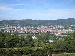 Panoramic view of Errenteria, from Mount San Marko | ||
| ||
 Errenteria Location in Spain  Errenteria Errenteria (Spain) | ||
| Coordinates: 43°18′45.06″N 1°53′55.55″W / 43.3125167°N 1.8987639°W | ||
| Country |
| |
| Autonomous community |
| |
| Province | Gipuzkoa | |
| Eskualdea | Donostialdea | |
| Government | ||
| • Mayor | Julen Mendoza Pérez (EH Bildu) | |
| Area | ||
| • Total | 32.26 km2 (12.46 sq mi) | |
| Population (2016) | ||
| • Total | 39,381 | |
| • Density | 1,220.74/km2 (3,161.7/sq mi) | |
| Demonym(s) | Errenteriar | |
| Time zone | UTC+1 (CET) | |
| • Summer (DST) | UTC+2 (CEST) | |
| Postal code | 20100 | |
| Official language(s) | Basque | |
| Website | Official website | |
.svg.png)
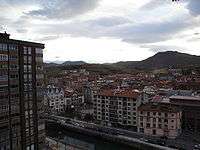
View of downtown Orereta
Errenteria (Basque: Errenteria/Orereta, Spanish: Rentería) is a town located in the province of Gipuzkoa in the Basque Autonomous Community, in the north of Spain, near the French border. The river Oiartzun cuts its way through the town, one that has undergone severe pollution up to recent times on its lower stage.
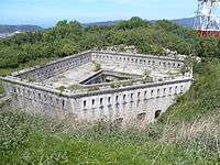
Fortress of Txoritokieta
Districts
- Agustinak/Agustinas
- Alaberga
- Beraun
- Kaputxinoak/Capuchinos
- Etxe Berriak/Casas Nuevas
- Gaztaño
- Erdialdea/Centro
- Fanderia
- Gabierrota
- Galtzaraborda
- Iztieta
- Lartzabal
- Listorreta
- Olibet - Ugarritze
- Ondartxo
- Perurena
- Pontika
- Zamalbide
Twin towns


See also
External links
- Official website (in Spanish) (in Basque)
- ERRENTERIA in the Bernardo Estornés Lasa - Auñamendi Encyclopedia (Euskomedia Fundazioa) (in Spanish)
| Authority control |
|---|
This article is issued from
Wikipedia.
The text is licensed under Creative Commons - Attribution - Sharealike.
Additional terms may apply for the media files.