RemoteView
|
| |
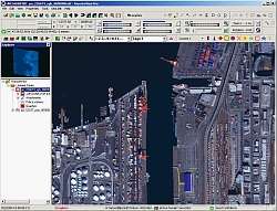 RemoteView main window with image loaded | |
| Developer(s) | Textron Systems |
|---|---|
| Initial release | 1996 |
| Stable release |
4.5
/ March 2017 |
| Written in | C++ |
| Operating system | Windows |
| Size | ≈650 MB |
| Available in | English |
| Type | Remote Sensing Application, GIS |
| License | Proprietary |
| Website |
www |
RemoteView is the family name of a group of software programs designed by Textron Systems Geospatial Solutions to aid in analyzing satellite or aerial images of the Earth's surface for the purpose of collecting and disseminating geospatial intelligence. The National Geospatial-Intelligence Agency (NGA) is a longtime user of RemoteView software.[1]
Overview
RemoteView is a widely available electronic light table application, initially developed and released commercially by Sensor Systems in 1996. An electronic light table application makes it possible for imagery analysts to review satellite images on a computer instead of examining film or printed photographs. RemoteView was originally written only for the Unix operating system, but as the US Department of Defense transitioned to the Windows operating system, Sensor Systems released a Windows-based version that soon became a primary tool used by the intelligence community. Overwatch acquired Sensor Systems and the RemoteView software in 2005.[2] Textron Systems acquired Overwatch in 2006.
RemoteView's main function is an imagery and geospatial analysis tool. It can display a wide array of imagery formats, elevation data sets, and vector data sets. Capabilities include image enhancements, photogrammetry, orthorectification, multispectral classification, pan sharpening, change detection, assisted search, location positioning, and 3D terrain visualization.[3] These features allow an intelligence analyst to review large-scale imagery and generate annotated reports on any findings.
RemoteView for Windows comes in two versions, RemoteView Desktop and RemoteView Pro. RemoteView Desktop is an entry-level imagery exploitation and analysis solution, for focusing on a single image at a time or reviewing the results of another analyst's work. RemoteView Pro is the flagship product offering a greater number of tools, extensions, and capabilities.
Extensions
Textron Systems Geospatial Solutions offers a series of extensions that add specialized capabilities to RemoteView.[4] These include:
- Virtual Mosaic – a tool for quickly joining more than four adjacent or overlapping images
- 3D Pro – a module that expands visualization tools to allow creating 3D virtual worlds for simulating real world conditions and planning missions
- RVConnect – a tool that enables automatic data sharing between RemoteView and Esri’s ArcMap software
- V-TRAC Basic – a complementary video player that allows analysis of full motion video recorded by UAVs
- V-TRAC Pro – expands the abilities of V-TRAC Basic to include mark-up and reporting tools
- GeoCatalog for Desktop – a complementary database that makes it easier to organize and retrieve geospatial data
See also
References
- ↑ "Overwatch Announces 5-Year Research Contract with National Geospatial-Intelligence Agency". Overwatch Press. Retrieved September 1, 2010.
- ↑ "Federal Information Technology Systems Announces the Acquisition of Sensor Systems, Inc" (PDF). Daroth Capital Press. Retrieved April 2005. Check date values in:
|accessdate=(help) - ↑ "RemoteView". Overwatch. Retrieved October 23, 2012.
- ↑ "RemoteView Extensions". Overwatch. Retrieved January 27, 2010.