Reckong Peo
| Reckong Peo | |
|---|---|
| Town | |
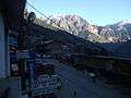
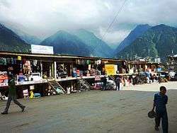 Main street, Reckong Peo, 2010 | |
 Reckong Peo Location in Himachal Pradesh, India  Reckong Peo Reckong Peo (India) | |
| Coordinates: 31°32′25″N 78°16′20″E / 31.540278°N 78.272222°ECoordinates: 31°32′25″N 78°16′20″E / 31.540278°N 78.272222°E | |
| Country |
|
| State | Himachal Pradesh |
| District | Kinnaur |
| Population | |
| • Total | 2,397 (1,529 males , 868 females) |
| Languages | |
| • Official | Hindi |
| Time zone | UTC+5:30 (IST) |
| Nearest city | Rampur, Bhaba Nagar, Kalpa, Pooh, Kumarsain, Ani, Morang, Kaza |
| Lok Sabha constituency | Mandi |
| Vidhan Sabha constituency | Kinnaur |
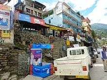
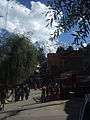
Downtown Rekong Peo
Reckong Peo, also spelled Rekong Peo and simply known as Peo by the local inhabitants, is headquarters of Kinnaur district, one of the twelve administrative districts of the Indian state of Himachal Pradesh.
At a height of 2,290 metres (7,513 ft), Reckong Peo is 260 kilometres (162 miles) from Shimla and seven kilometres (4⅓ miles) from Powari. Earlier Kalpa was the headquarters later changed to Reckong Peo, named after group of people who used to own this place in ancient times.
Gallery

 Entrance of Recong Peo Hospital in Himachal Pradesh 2015
External links
- Fresh spell of snowfall and light showers in the upper reaches of the hill state
- Info on Reckong Peo from Government of India portal
| Wikimedia Commons has media related to Reckong Peo. |
This article is issued from
Wikipedia.
The text is licensed under Creative Commons - Attribution - Sharealike.
Additional terms may apply for the media files.