Reisbach (Vils)
| Reisbach | ||
|---|---|---|
| ||
 Reisbach Location of Reisbach within Dingolfing-Landau district 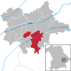 | ||
| Coordinates: 48°34′N 12°38′E / 48.567°N 12.633°ECoordinates: 48°34′N 12°38′E / 48.567°N 12.633°E | ||
| Country | Germany | |
| State | Bavaria | |
| Admin. region | Niederbayern | |
| District | Dingolfing-Landau | |
| Government | ||
| • Mayor | Josef Steinberger (CSU) | |
| Area | ||
| • Total | 94.16 km2 (36.36 sq mi) | |
| Elevation | 408 m (1,339 ft) | |
| Population (2017-12-31)[1] | ||
| • Total | 7,763 | |
| • Density | 82/km2 (210/sq mi) | |
| Time zone | CET/CEST (UTC+1/+2) | |
| Postal codes | 94419 | |
| Dialling codes | 08734 08735 (Bachham) | |
| Vehicle registration | DGF | |
| Website |
www | |

Reisbach is the name of a municipality in Bavaria. It belongs to the administrative region of Niederbayern.
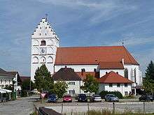 Church St. Michael |
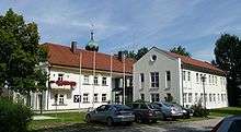 Citty hall of Reisbach |
Neighbouring communities
The neighbouring communities clockwise: Mamming, Landau an der Isar, Simbach (bei Landau), Falkenberg (Niederbayern), Rimbach (Niederbayern), Gangkofen, Marklkofen and Gottfrieding
Places adjacent to Reisbach (Vils) | ||||||||||
|---|---|---|---|---|---|---|---|---|---|---|
| ||||||||||
Villages in the municipality
- Foto Reisbach, (2007-2009);
- Englmannsberg
- Griesbach
- Niederhausen
- Oberhausen
- Obermünchsdorf
- Reith
- Thannenmais
References
- ↑ "Fortschreibung des Bevölkerungsstandes". Bayerisches Landesamt für Statistik und Datenverarbeitung (in German). September 2018.
Towns and municipalities in Dingolfing-Landau | ||
|---|---|---|
This article is issued from
Wikipedia.
The text is licensed under Creative Commons - Attribution - Sharealike.
Additional terms may apply for the media files.