Rehlingen-Siersburg
| Rehlingen-Siersburg | ||
|---|---|---|
| ||
 Rehlingen-Siersburg Location of Rehlingen-Siersburg within Saarlouis district 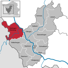  | ||
| Coordinates: 49°22′7″N 6°40′43″E / 49.36861°N 6.67861°ECoordinates: 49°22′7″N 6°40′43″E / 49.36861°N 6.67861°E | ||
| Country | Germany | |
| State | Saarland | |
| District | Saarlouis | |
| Government | ||
| • Mayor | Martin Silvanus (SPD) | |
| Area | ||
| • Total | 61.16 km2 (23.61 sq mi) | |
| Elevation | 193 m (633 ft) | |
| Population (2017-12-31)[1] | ||
| • Total | 14,422 | |
| • Density | 240/km2 (610/sq mi) | |
| Time zone | CET/CEST (UTC+1/+2) | |
| Postal codes | 66780 | |
| Dialling codes | 06835, 06869, 06833, 06861 | |
| Vehicle registration | SLS | |
| Website | www.rehlingen-siersburg.de | |

Rehlingen-Siersburg is a municipality in the district of Saarlouis, in Saarland, Germany. It is situated on the river Saar, approx. 8 km northwest of Saarlouis, and 30 km northwest of Saarbrücken.
| Wikimedia Commons has media related to Rehlingen-Siersburg. |
Towns and municipalities in Saarlouis (district) | ||
|---|---|---|
References
- ↑ "Fläche und Bevölkerung - Stand: 31.12.2017 (Basis Zensus 2011)" (PDF). Statistisches Amt des Saarlandes (in German). September 2018.
This article is issued from
Wikipedia.
The text is licensed under Creative Commons - Attribution - Sharealike.
Additional terms may apply for the media files.