Rednitz
| Rednitz | |
|---|---|
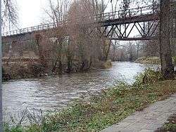 canoe course and old railway bridge in Fürth-Weikershof | |
| Country | Germany |
| Physical characteristics | |
| River mouth |
Regnitz 49°29′11″N 10°59′12″E / 49.48639°N 10.98667°ECoordinates: 49°29′11″N 10°59′12″E / 49.48639°N 10.98667°E |
| Length | 46.4 km (28.8 mi) [1] |
| Basin features | |
| Progression | Regnitz→ Main→ Rhine→ North Sea |
| Basin size | 2,118 km2 (818 sq mi) [1] |
The Rednitz is a 46 km long river in Franconia, Germany, tributary of the Regnitz (more precisely: its southern, left headstream). The Rednitz is formed by the confluence of the rivers Fränkische Rezat and Schwäbische Rezat, in Georgensgmünd (district of Roth). The Rednitz flows north through Roth bei Nürnberg, Schwabach and the southwestern quarters of Nuremberg. The Rednitz joins the Pegnitz to form the Regnitz in Fürth.
Sources
Franz X. Bogner: Rednitz und Regnitz. Eine Luftbildreise von Weißenburg bis Bamberg. Luftbildband. Verlag Fränkischer Tag, Bamberg 2007 ISBN 978-3-936897-47-0
References
- 1 2 Complete table of the Bavarian Waterbody Register by the Bavarian State Office for the Environment (xls, 10.3 MB)
This article is issued from
Wikipedia.
The text is licensed under Creative Commons - Attribution - Sharealike.
Additional terms may apply for the media files.