Redbank Gorge
Coordinates: 23°45′00″S 132°58′43″E / 23.750082°S 132.978670°E
| Redbank Gorge | |
| Gorge | |
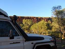 View of Redbank Gorge from nearby road | |
| Official name: Redbank Gorge | |
| Country | Australia |
|---|---|
| State | Northern Territory |
| Municipality | Namatjira |
| Part of | MacDonnell Ranges |
| Coordinates | 23°45′00″S 132°58′43″E / 23.750082°S 132.978670°E |
Redbank Gorge (commonly Red Bank Gorge), is a gorge located in the Northern Territory of Australia, 156 km west of Alice Springs. It is situated at the bottom of Mount Sonder.[1] The gorge is part of the West MacDonnell National Park, which has an area of approximately 2,568 square kilometres (992 sq mi).
Features
The area features camping facilities at the Woodland and Ridgetop campgrounds, which contain amenities such as a toilet and fire pit, however fees apply to use these locations.[2] The gorges can be accessed from the nearby Larapinta and Namatjira drives.[1]
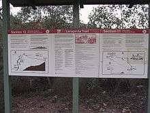
An information board at the gorge's location on the Larapinta Trail.
References
- 1 2 "Redbank Gorge". northernterritory.com. Retrieved 2018-05-27.
- ↑ "Northern Territory For Everyone: Redbank Gorge". www.australiaforeveryone.com.au. Retrieved 2018-05-27.
External links
This article is issued from
Wikipedia.
The text is licensed under Creative Commons - Attribution - Sharealike.
Additional terms may apply for the media files.