Population
| Historical population |
|---|
| Year | Pop. | ±% p.a. |
|---|
| 1768 | 74 | — |
|---|
| 1869 | 692 | +2.24% |
|---|
| 1872 | 763 | +3.31% |
|---|
| 1924 | 1,000 | +0.52% |
|---|
| 1968 | 5,400 | +3.91% |
|---|
| | Year | Pop. | ±% p.a. |
|---|
| 1982 | 6,091 | +0.86% |
|---|
| 1991 | 14,000 | +9.69% |
|---|
| 1999 | 17,200 | +2.61% |
|---|
| 2001 | 17,634 | +1.25% |
|---|
| 2011 | 22,030 | +2.25% |
|---|
|
History
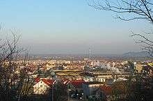
View of Reda
In 1308, the town was first founded within Teutonic Order territory, and was first mentioned in documents in 1357. It first was under Poland rule in 1466, as part of its Royal Prussia province. It was lost to Prussia for nearly 150 years through the First Partition of Poland of 1772, and in World War II, was annexed from Poland by Germany into the latter's Danzig-West Prussia province. After the war, the town was again returned to Poland. In 1967, the 5,400 resident town gained the name Reda, and after growth began to accelerate in 1982, its population had more than tripled to above 17,000 residents by 1999.
External links
 |
Wikimedia Commons has media related to Reda. |
Authority control  | |
|---|