Red Feather Lakes, Colorado
| Red Feather Lakes | |
|---|---|
| Census-designated place (CDP) | |
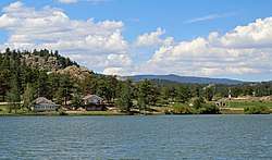 Ramona Lake, with the community park on the right. | |
 Location of Red Feather Lakes shown within Colorado | |
| Coordinates: 40°48′28″N 105°34′43″W / 40.80778°N 105.57861°W | |
| Country |
|
| State |
|
| County | Larimer County[1] |
| Government | |
| • Type | unincorporated community |
| Area | |
| • Total | 37.2 sq mi (96.4 km2) |
| • Land | 36.7 sq mi (95.0 km2) |
| • Water | 0.6 sq mi (1.4 km2) 1.48% |
| Elevation | 7,890 ft (2,405 m) |
| Population (2000) | |
| • Total | 525 |
| • Density | 14.3/sq mi (5.5/km2) |
| Time zone | UTC-7 (MST) |
| • Summer (DST) | UTC-6 (MDT) |
| ZIP code[2] | 80545 |
| Area code(s) | 970 |
| FIPS code | 08-63320 |
| GNIS feature ID | 0170220 |
Red Feather Lakes is a census-designated place (CDP) in Larimer County, Colorado, United States. The population was 525 at the 2000 census.[3] The Red Feather Lakes Post Office has the ZIP Code 80545.[2] Located in the Rocky Mountains northwest of Fort Collins, this is a rustic mountain village surrounded by the Roosevelt National Forest. The Red Feather Lakes area offers beautiful scenery, diverse wildlife, hiking trails and cozy mountain retreats.
Presently, the village has three small general stores with gas pump, groceries, ATM and gift shop, an Ace hardware store, an outdoor sports shop, a coffee shop, a community library, small antique store, and post office. Several rustic mountain restaurants are located in the community.[4]
Gnome Road (aka, “Elf Lane”) is mountain dirt road in the village. Hikers strolling and cars cruising the scenic road will find ceramic elves and gnomes as well as fairy doors and faces among the trees, boulders and bushes.[5][4]
Geography
Red Feather Lakes is located at 40°48′28″N 105°34′43″W / 40.80778°N 105.57861°W (40.807820, -105.578641).[6]
According to the United States Census Bureau, the CDP has a total area of 37.2 square miles (96 km2), of which, 36.7 square miles (95 km2) is land and 0.6 square miles (1.6 km2) (1.48%) is water.
History
Other than Native Americans, only occasional hunters and trappers passed through the Red Feather Lakes area until the middle of the 19th century. The first known settler was John Hardin, who built a cabin about two miles from the current Red Feather Lakes village in 1871. Other settlers, many of them families of Hardin's eleven surviving children, homesteaded and built nearby. In these early years, the settlers were primarily ranchers, but another important activity was lumbering. The trails in the area, some of which eventually became roads, were built by tie hacks, who hauled their ties down to what is now Tie Siding, Wyoming, where they were used in building the transcontinental railroad.[7]
The first government survey, in 1879, showed only one lake in the region: what is now Creedmore Lake, several miles away. As the area developed, networks of toll roads, lakes and water ditches appeared. By the beginning of the twentieth century water rights had become a major issue in the region, and who had ownership of the water in the various streams, man-made lakes, and diversions continued to spark legal battles until a Supreme Court decision in 1921 awarded a major portion of water being diverted from the Laramie River tributaries to competing claims in Wyoming.[7]:14
In September, 1886, gold was discovered a few miles south, and the town of Manhattan was platted at the site in 1887.[8] Manhattan grew to a peak of 300 inhabitants in 1898, but substantial gold was never obtained, and it became a ghost town a few years later.
By 1895, the population was sufficient that a school district was established and a schoolhouse constructed. Timbering and sawmills grew in importance in the area, and in 1902 a National Forest Reserve (later to become part of Roosevelt National Forest) was established, principally to exercise some control over the helter-skelter timbering.[7]
Recreation was not of much importance in the early years, and first appeared when the Fort Collins YMCA built a camp in 1919. Interest in the area as a summer retreat for urban dwellers in Fort Collins and other Frontrange communities grew rapidly, and in 1923, the name "Red Feather" made its first appearance when the Red Feather Mountain Lakes Association was formed with the objective of developing recreational homes (cabins) on 4320 acres. The name was stimulated by Princess Tsianina Redfeather, a native American girl who was touring in concert with the composer Charles Wakefield Cadman. Purportedly, the namesake was Princes Redfeather's grandfather, Chief Redfeather, whose grave was supposed to be in the area.[7]:29[9][10]

The Red Feather Mountain Lakes Association (whose assets were acquired by the Red Feather Investment Co. five years later) had grand plans. The planning map included a golf course, tennis courts, rodeo grounds, a ranch school, a rifle range, and many other recreational facilities. Of these, only a nine-hole golf course materialized. Several hotels were planned; one was built in 1924. A silver fox farm was also part of the plan, and this was begun early in the development with twenty pairs of foxes bought in New York. Though it did not succeed at the scale the developers envisioned, this development was responsible for the growth of Red Feather Lakes as a fishing and summer recreational area. In 1925, the investors claimed the sale of 1900 lots and orders for 100 cabins. Most of these lots were one-eighth acre in size, which sufficed for a cabin and the requisite outhouse. Growth was slow, and was impeded by the Great Depression and by World War II. Many of the original lots survive today, and original cabins can be found if one looks carefully behind and beneath various modern additions.[7][9]
In 1933, President Roosevelt established the Civilian Conservation Corps (CCC). Several CCC camps were operated in the region, including one on the site of the Manhattan ghost town and, starting in 1935, one not far from the village. Young men working in the camps improved roads, cleared forests, engaged in firefighting, and constructed the original fire tower at the top of Deadman Mountain. During WWII, as the CCC was phased out, the camp near the village was sold as salvage, and another became a POW camp.[7]
The silver fox farm continued into the 1950s, by which time furs were in little demand. The property was sold around 1960, and is now a part of the Fox Acres Community (Golf Club and residences). The original fox farm caretaker's house, with its second-story cupola that overlooked the fox pens, is still in use on the property.
The Rural Electrification Administration (REA) brought electricity to the Red Feather Lakes area in 1952. In the ensuing years, new buildings gradually changed the face of the village, including a fire station and library.[7] Most recently (in 2015), the arrival of a large Ace Hardware store has dramatically increased the village traffic.
Detailed historical information is gathered and maintained by the Red Feather Historical Society. The group maintains a website at http://www.redfeatherhistoricalsociety.org, and operates a museum in a historical cabin in the village.
Demographics
| Historical population | |||
|---|---|---|---|
| Census | Pop. | %± | |
| U.S. Decennial Census[11] | |||
As of the census[3] of 2000, there were 525 people, 262 households, and 175 families residing in the CDP. The population density was 14.3 people per square mile (5.5/km²). There were 1,106 housing units at an average density of 30.2 per square mile (11.6/km²). The racial makeup of the CDP was 96.95% White, 0.95% Native American, 0.19% Asian, 0.19% from other races, and 1.71% from two or more races. Hispanic or Latino of any race were 2.29% of the population.
There were 262 households out of which 14.1% had children under the age of 18 living with them, 61.5% were married couples living together, 2.7% had a female householder with no husband present, and 33.2% were non-families. 27.1% of all households were made up of individuals and 10.3% had someone living alone who was 65 years of age or older. The average household size was 2.00 and the average family size was 2.40.
In the CDP, the population was spread out with 13.0% under the age of 18, 3.0% from 18 to 24, 18.7% from 25 to 44, 40.4% from 45 to 64, and 25.0% who were 65 years of age or older. The median age was 54 years. For every 100 females, there were 97.4 males. For every 100 females age 18 and over, there were 97.0 males.
The median income for a household in the CDP was $33,527, and the median income for a family was $40,714. Males had a median income of $36,250 versus $43,333 for females. The per capita income for the CDP was $19,231. About 3.2% of families and 8.4% of the population were below the poverty line, including 26.7% of those under age 18 and 9.5% of those age 65 or over.
Red Feather Lakes Area
Surrounding Red Feather Lakes Area
Red Feather Lakes village is surrounded by the 612,000-acre Roosevelt National Forest encompassing the south part of the Laramie Mountains, a range of moderately high peaks—8,000 feet (2,400 m) to 11,007 feet (3,355 m) above sea level—on the eastern edge of the Rocky Mountains near the Colorado-Wyoming border. Aspen, ponderosa pine, lakes and streams, and rock outcroppings define the countryside. Activities in the area include hiking, horseback riding, canoeing and boating, fishing, biking, off-road vehicle use, hunting, ice-fishing, cross-country skiing, snowshoeing, ice skating and sledding. Wildlife include moose, deer, elk, big horn sheep, black bear, mountain lions, bobcats, squirrels, chipmunks, rabbits, marmots, foxes and many species of birds including quail, grouse, wild turkey, and bald and golden eagles.
Colorado State Wildlife Areas with lakes open to the public in close proximity of Red Feather Lakes Village are Dowdy Lake (112 acres), Parvin Lake (62 acres), West Lake (32 acres), and Lake Bellaire (11 acres). Public lakes located a few miles north of the village include the three Creedmore Lakes and Lost Lake. Eight private lakes within the Village require a membership to access.
Crystal Lakes Development
Crystal Lakes is a private mountain subdivision northwest of and adjacent to Red Feather Lakes village and within the Red Feather Lakes Zip Code area. Established in 1969, Crystal Lakes contains approximately 1,600 lots over more than 4800 acres at elevations ranging from 8,000 to 9,500 feet above sea level. More than 800 dwellings ranging from modest cabins to spacious mountain homes have been built to date. Crystal Lake (Panhandle Reservoir) and smaller ponds and streams offer fishing, boating and hiking. Fishing in Crystal Lakes is private and requires a pass.
Fox Acres Development
Fox Acres is a mountain community, just north of Red Feather Lakes Village, that consists of luxury homes, townhomes, duplexes, and condominiums. Amenities of the community include championship golf, fishing, fitness trail, tennis, mountain lake swim beach, and bocce. Fifteen mountain lakes offer trout fishing. The 18-hole, 6,500 yard, golf course at Fox Acres is at an elevation of 8,300 feet. The Clubhouse at Fox Acres Country Club offers luxury dining. Annual homeowner fees provide for road maintenance, open space care, water treatment, waste water treatment with a sewer system, snow removal, trash collection, and security.
Creedmore Lakes
The three remote lakes of the Creedmore Lakes system are all nestled in the Roosevelt National Forest on the north slope of the Colorado Rockies, north of the town of Red Feather Lakes. The area offers hiking on trails in the area, camping at several dispersed primitive areas, and fishing in stocked lakes. Creedmore Lakes Trail is a 0.7 mile out-and-back trail to the first of the three lakes.
See also
References
- ↑ "US Board on Geographic Names". United States Geological Survey. 2007-10-25. Retrieved 2008-01-31.
- 1 2 "ZIP Code Lookup" (JavaScript/HTML). United States Postal Service. December 14, 2006. Retrieved December 14, 2006.
- 1 2 "American FactFinder". United States Census Bureau. Retrieved 2008-01-31.
- 1 2 Boster, Seth (June 24, 2017). "Colorful Colorado: At a remote village, magic in the mountains". The Gazette: Web Edition. Colorado Springs, CO. Retrieved 5 August 2017.
- ↑ "Gnome Road". Atlas Obscura. Atlas Obscura. Retrieved 4 Aug 2017.
- ↑ "US Gazetteer files: 2010, 2000, and 1990". United States Census Bureau. 2011-02-12. Retrieved 2011-04-23.
- 1 2 3 4 5 6 7 Swanson, Evadene Burris (1971). Red Feather Lakes: the first hundred years (1986, reprinted 2001 ed.). Red Feather Lakes, Colorado: Red Feather Historical Society. ISBN 0-9679817-4-3.
- ↑ The Colorado Magazine. State Historical and Natural History Society of Colorado, State Museum. 1971. p. 147.
- 1 2 "Local History". Red Feather Historical Society website. Red Feather Historical Society. Retrieved 2 Aug 2017.
- ↑ Dawson, John Frank. Place names in Colorado: why 700 communities were so named, 150 of Spanish or Indian origin. Denver, CO: The J. Frank Dawson Publishing Co. p. 43.
- ↑ "Census of Population and Housing". Census.gov. Retrieved June 4, 2016.
| Wikimedia Commons has media related to Pennoyer Amethyst Mine. |
Municipalities and communities of Larimer County, Colorado, United States | ||
|---|---|---|
| Cities | 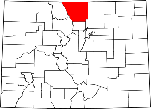 | |
| Towns | ||
| CDPs | ||
| Unincorporated communities | ||
| Ghost towns | ||
| Footnotes | ‡This populated place also has portions in an adjacent county or counties | |
Coordinates: 40°48′28″N 105°34′43″W / 40.80782°N 105.578641°W