Recoules-Prévinquières
| Recoules-Prévinquières | ||
|---|---|---|
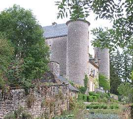 The Château of Recoules | ||
| ||
 Recoules-Prévinquières Location within Occitanie region  Recoules-Prévinquières | ||
| Coordinates: 44°20′30″N 2°58′11″E / 44.3417°N 2.9697°ECoordinates: 44°20′30″N 2°58′11″E / 44.3417°N 2.9697°E | ||
| Country | France | |
| Region | Occitanie | |
| Department | Aveyron | |
| Arrondissement | Millau | |
| Canton | Tarn et Causses | |
| Government | ||
| • Mayor (2008–2014) | Pierre Vermande | |
| Area1 | 25.2 km2 (9.7 sq mi) | |
| Population (2008)2 | 465 | |
| • Density | 18/km2 (48/sq mi) | |
| Time zone | UTC+1 (CET) | |
| • Summer (DST) | UTC+2 (CEST) | |
| INSEE/Postal code | 12196 /12150 | |
| Elevation |
609–1,040 m (1,998–3,412 ft) (avg. 630 m or 2,070 ft) | |
|
1 French Land Register data, which excludes lakes, ponds, glaciers > 1 km2 (0.386 sq mi or 247 acres) and river estuaries. 2 Population without double counting: residents of multiple communes (e.g., students and military personnel) only counted once. | ||

Recoules-Prévinquières is a former commune in the Aveyron department in southern France. On 1 January 2016, it was merged into the new commune of Sévérac-d'Aveyron.[1]
Population
| Historical population | ||
|---|---|---|
| Year | Pop. | ±% |
| 1962 | 438 | — |
| 1968 | 510 | +16.4% |
| 1975 | 503 | −1.4% |
| 1982 | 418 | −16.9% |
| 1990 | 444 | +6.2% |
| 1999 | 428 | −3.6% |
| 2008 | 465 | +8.6% |
See also
References
- ↑ Arrêté préfectoral 6 November 2015
| Wikimedia Commons has media related to Recoules-Prévinquières. |
This article is issued from
Wikipedia.
The text is licensed under Creative Commons - Attribution - Sharealike.
Additional terms may apply for the media files.