Raukokore
| Raukokore | |
|---|---|
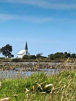 Raukokore's Anglican church | |
 Raukokore | |
| Coordinates: 37°38′38″S 177°52′35″E / 37.64389°S 177.87639°E | |
| Country |
|
| Region | Bay of Plenty |
| Territorial authority | Opotiki District |
| Ward | Coast |
Raukokore is a small settlement close to the East Cape in the northeastern North Island of New Zealand. It is located on State Highway 35, close to the mouth of the Raukokore River, 40 kilometres to the west of Hicks Bay.
Raukokore's most notable feature is its Anglican church,' Christ Church', a landmark of the East Cape region, which stands isolated close to the shore of Papatea Bay. The church was named as one of the East Cape/Gisborne region's "101 must-do" sites by the New Zealand Automobile Association.[1] The church was designed and built by Duncan Stirling in 1894. Stirling married local Raukokore chief, Mihi Kotukotuku in the church in 1896. The church is listed as a Category 1 Historic Place under the New Zealand Historic Places Trust. http://www.heritage.org.nz/the-list/details/3471
It is administered by the Opotiki District Council.