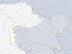
Ratta, Azad Kashmir
| Ratta | |
|---|---|
 Ratta | |
| Coordinates: 33°21′25″N 73°39′32″E / 33.357°N 73.659°ECoordinates: 33°21′25″N 73°39′32″E / 33.357°N 73.659°E | |
| Country | Template:Country data Kashmir |
| State | Azad Kashmir |
| Population | |
| • Estimate () | 3,152 |
| Time zone | UTC+5 (PST) |
Ratta is the largest village in Dadyal in the Mirpur District of Azad Kashmir. It is located 70 km (43 mi) east of Islamabad, Pakistan. Residents of Ratta sometimes add the word Ratvi to their surname. The word Ratta derives from the words Jatta na malla which translates into The place of Jatts. Jatts are part of the caste system found in the south Asian subcontinent.[1] However, as people moved into the area, but who were not Jatts but of a different caste, it slowly became known as Ratta. Many people from other parts of Azad Kashmir villages have moved to Ratta for a better life. The first travelers from this entire region to the west were from Ratta.
Demography
According to the 1998 census of Pakistan, its population was 3,152.[2]
References
- ↑ "Jat | caste". Encyclopedia Britannica. Retrieved 2017-05-08.
- ↑ https://www.scribd.com/doc/2510797/Village-List-Mirpur-AJK
This article is issued from
Wikipedia.
The text is licensed under Creative Commons - Attribution - Sharealike.
Additional terms may apply for the media files.